You are here: Home > Network List > GT - Global Telemetered Seismograph Network (USAF/USGS) Stations List
> Station LBTB Lobatse, Botswana, Africa > Earthquake Result Viewer
LBTB Lobatse, Botswana, Africa - Earthquake Result Viewer
| Earthquake location: |
Chile-Bolivia Border Region |
| Earthquake latitude/longitude: |
-22.3/-67.9 |
| Earthquake time(UTC): |
2005/11/17 (321) 19:26:56 GMT |
| Earthquake Depth: |
163 km |
| Earthquake Magnitude: |
6.0 MB, 6.9 MW, 6.8 MW |
| Earthquake Catalog/Contributor: |
WHDF/NEIC |
|
| Network: |
GT Global Telemetered Seismograph Network (USAF/USGS) |
| Station: |
LBTB Lobatse, Botswana, Africa |
| Lat/Lon: |
25.02 S/25.60 E |
| Elevation: |
1128 m |
|
| Distance: |
83.8 deg |
| Az: |
114.369 deg |
| Baz: |
248.384 deg |
| Ray Param: |
0.04554569 |
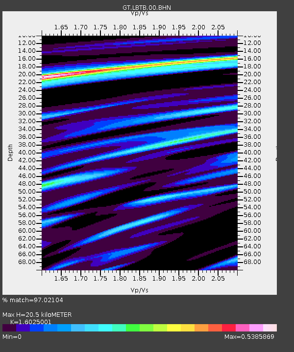
| Estimated Moho Depth: |
20.5 km |
| Estimated Crust Vp/Vs: |
1.60 |
| Assumed Crust Vp: |
6.459 km/s |
| Estimated Crust Vs: |
4.031 km/s |
| Estimated Crust Poisson's Ratio: |
0.18 |
|
| Radial Match: |
97.02104 % |
| Radial Bump: |
254 |
| Transverse Match: |
85.34839 % |
| Transverse Bump: |
400 |
| SOD ConfigId: |
2422 |
| Insert Time: |
2010-02-27 02:06:07.089 +0000 |
| GWidth: |
2.5 |
| Max Bumps: |
400 |
| Tol: |
0.001 |
|

Signal To Noise
| Channel | StoN | STA | LTA |
| GT:LBTB:00:BHN:20051117T19:38:36.398994Z | 1.2678833 | 2.2148475E-7 | 1.746886E-7 |
| GT:LBTB:00:BHE:20051117T19:38:36.398994Z | 7.939889 | 9.501545E-7 | 1.196685E-7 |
| GT:LBTB:00:BHZ:20051117T19:38:36.398994Z | 18.176645 | 2.5322959E-6 | 1.3931592E-7 |
| Arrivals |
| Ps | 2.0 SECOND |
| PpPs | 8.0 SECOND |
| PsPs/PpSs | 10.0 SECOND |


