You are here: Home > Network List > G - GEOSCOPE Stations List
> Station CLF Chambon la Foret observatory, France > Earthquake Result Viewer
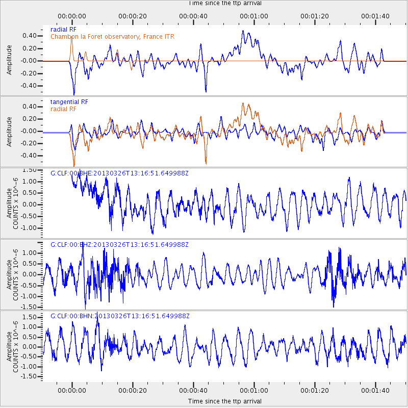
CLF Chambon la Foret observatory, France - Earthquake Result Viewer
*The percent match for this event was below the threshold and hence no stack was calculated.
| Earthquake location: |
Near Coast Of Guerrero, Mexico |
| Earthquake latitude/longitude: |
16.2/-98.2 |
| Earthquake time(UTC): |
2013/03/26 (085) 13:04:48 GMT |
| Earthquake Depth: |
10 km |
| Earthquake Magnitude: |
5.5 MB, 5.0 MS, 5.5 MW, 5.4 MW |
| Earthquake Catalog/Contributor: |
WHDF/NEIC |
|
| Network: |
G GEOSCOPE |
| Station: |
CLF Chambon la Foret observatory, France |
| Lat/Lon: |
48.03 N/2.26 E |
| Elevation: |
145 m |
|
| Distance: |
84.9 deg |
| Az: |
41.517 deg |
| Baz: |
288.415 deg |
| Ray Param: |
$rayparam |
*The percent match for this event was below the threshold and hence was not used in the summary stack. |
|
| Radial Match: |
38.43349 % |
| Radial Bump: |
400 |
| Transverse Match: |
33.784153 % |
| Transverse Bump: |
400 |
| SOD ConfigId: |
506627 |
| Insert Time: |
2013-06-07 04:02:50.630 +0000 |
| GWidth: |
2.5 |
| Max Bumps: |
400 |
| Tol: |
0.001 |
|
Signal To Noise
| Channel | StoN | STA | LTA |
| G:CLF:00:BHZ:20130326T13:16:51.649988Z | 2.1372123 | 6.618787E-7 | 3.0969252E-7 |
| G:CLF:00:BHN:20130326T13:16:51.649988Z | 1.0561655 | 8.0645356E-7 | 7.6356747E-7 |
| G:CLF:00:BHE:20130326T13:16:51.649988Z | 1.1620203 | 6.665078E-7 | 5.735767E-7 |
| Arrivals |
| Ps | |
| PpPs | |
| PsPs/PpSs | |


