You are here: Home > Network List > UW - Pacific Northwest Regional Seismic Network Stations List
> Station OMAK Colville Reservation, Omak, WA, USA > Earthquake Result Viewer
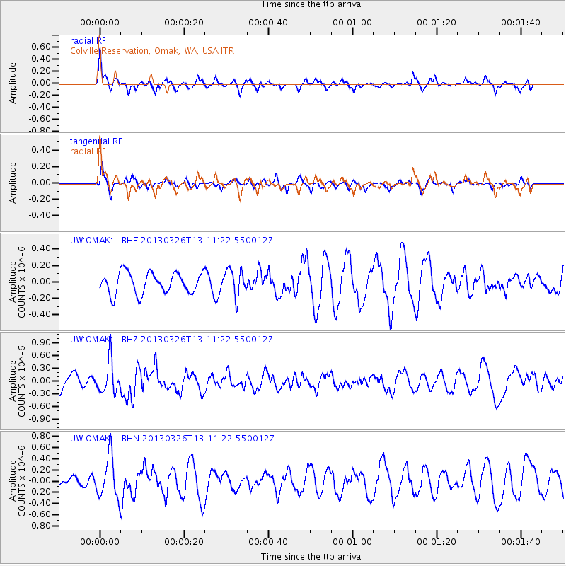
OMAK Colville Reservation, Omak, WA, USA - Earthquake Result Viewer
*The percent match for this event was below the threshold and hence no stack was calculated.
| Earthquake location: |
Near Coast Of Guerrero, Mexico |
| Earthquake latitude/longitude: |
16.2/-98.2 |
| Earthquake time(UTC): |
2013/03/26 (085) 13:04:48 GMT |
| Earthquake Depth: |
10 km |
| Earthquake Magnitude: |
5.5 MB, 5.0 MS, 5.5 MW, 5.4 MW |
| Earthquake Catalog/Contributor: |
WHDF/NEIC |
|
| Network: |
UW Pacific Northwest Regional Seismic Network |
| Station: |
OMAK Colville Reservation, Omak, WA, USA |
| Lat/Lon: |
48.36 N/119.33 W |
| Elevation: |
696 m |
|
| Distance: |
36.5 deg |
| Az: |
336.095 deg |
| Baz: |
144.282 deg |
| Ray Param: |
$rayparam |
*The percent match for this event was below the threshold and hence was not used in the summary stack. |
|
| Radial Match: |
60.65244 % |
| Radial Bump: |
359 |
| Transverse Match: |
54.93447 % |
| Transverse Bump: |
365 |
| SOD ConfigId: |
506627 |
| Insert Time: |
2013-06-07 04:07:13.862 +0000 |
| GWidth: |
2.5 |
| Max Bumps: |
400 |
| Tol: |
0.001 |
|
Signal To Noise
| Channel | StoN | STA | LTA |
| UW:OMAK: :BHZ:20130326T13:11:22.550012Z | 1.1415718 | 3.9131245E-7 | 3.4278395E-7 |
| UW:OMAK: :BHN:20130326T13:11:22.550012Z | 4.400042 | 3.866178E-7 | 8.7866844E-8 |
| UW:OMAK: :BHE:20130326T13:11:22.550012Z | 1.272421 | 1.6179331E-7 | 1.2715391E-7 |
| Arrivals |
| Ps | |
| PpPs | |
| PsPs/PpSs | |


