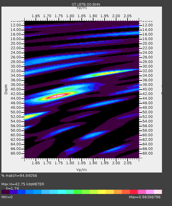
LBTB Lobatse, Botswana, Africa - Earthquake Result Viewer

Earthquake location: Andaman Islands, India Region
Earthquake latitude/longitude: 11.0/91.8
Earthquake time(UTC): 2008/06/27 (179) 11:40:13 GMT
Earthquake Depth: 17 km
Earthquake Magnitude: 6.4 MB, 6.7 MS, 6.6 MW, 6.6 MW
Earthquake Catalog/Contributor: WHDF/NEIC
Network: GT Global Telemetered Seismograph Network (USAF/USGS)
Station: LBTB Lobatse, Botswana, Africa
Lat/Lon: 25.02 S/25.60 E
Elevation: 1128 m
Distance: 73.8 deg
Az: 239.851 deg
Baz: 69.356 deg
Ray Param: 0.05276257
Estimated Moho Depth: 42.75 km
Estimated Crust Vp/Vs: 1.74
Assumed Crust Vp: 6.459 km/s
Estimated Crust Vs: 3.712 km/s
Estimated Crust Poisson's Ratio: 0.25
Radial Match: 94.84056 %
Radial Bump: 336
Transverse Match: 88.24193 %
Transverse Bump: 400
SOD ConfigId: 2504
Insert Time: 2010-02-27 02:06:26.657 +0000
GWidth: 2.5
Max Bumps: 400
Tol: 0.001

Signal To Noise

ChannelStoNSTALTA
GT:LBTB:00:BHN:20080627T11:51:15.950022Z11.2964321.917098E-61.6970829E-7
GT:LBTB:00:BHE:20080627T11:51:15.950022Z1.34639551.5740258E-71.1690665E-7
GT:LBTB:00:BHZ:20080627T11:51:15.950022Z3.62639387.668323E-72.1145863E-7
Arrivals
Ps5.1 SECOND
PpPs18 SECOND
PsPs/PpSs23 SECOND