You are here: Home > Network List > GT - Global Telemetered Seismograph Network (USAF/USGS) Stations List
> Station LBTB Lobatse, Botswana, Africa > Earthquake Result Viewer
LBTB Lobatse, Botswana, Africa - Earthquake Result Viewer
| Earthquake location: |
South Sandwich Islands Region |
| Earthquake latitude/longitude: |
-58.2/-22.1 |
| Earthquake time(UTC): |
2008/06/30 (182) 06:17:44 GMT |
| Earthquake Depth: |
19 km |
| Earthquake Magnitude: |
6.1 MB, 6.7 MS, 7.0 MW, 6.9 MW |
| Earthquake Catalog/Contributor: |
WHDF/NEIC |
|
| Network: |
GT Global Telemetered Seismograph Network (USAF/USGS) |
| Station: |
LBTB Lobatse, Botswana, Africa |
| Lat/Lon: |
25.02 S/25.60 E |
| Elevation: |
1128 m |
|
| Distance: |
47.2 deg |
| Az: |
66.227 deg |
| Baz: |
212.263 deg |
| Ray Param: |
0.070152186 |
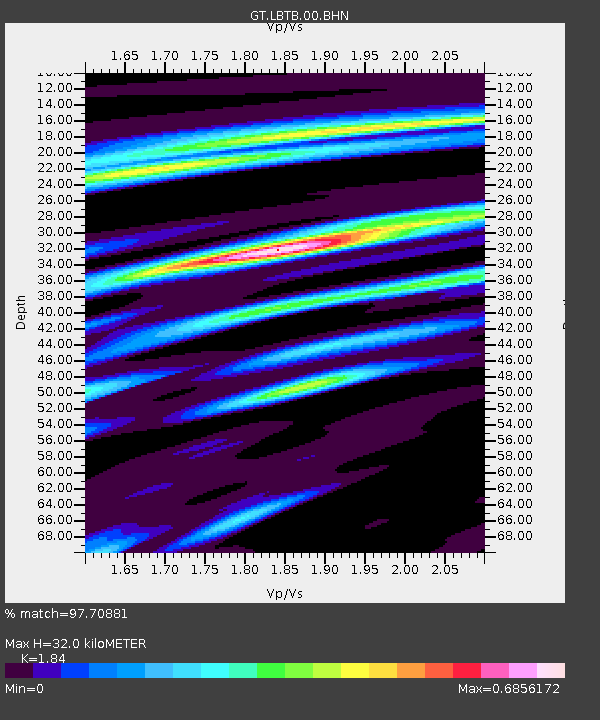
| Estimated Moho Depth: |
32.0 km |
| Estimated Crust Vp/Vs: |
1.84 |
| Assumed Crust Vp: |
6.459 km/s |
| Estimated Crust Vs: |
3.511 km/s |
| Estimated Crust Poisson's Ratio: |
0.29 |
|
| Radial Match: |
97.70881 % |
| Radial Bump: |
241 |
| Transverse Match: |
80.93908 % |
| Transverse Bump: |
400 |
| SOD ConfigId: |
2504 |
| Insert Time: |
2010-02-27 02:06:29.370 +0000 |
| GWidth: |
2.5 |
| Max Bumps: |
400 |
| Tol: |
0.001 |
|

Signal To Noise
| Channel | StoN | STA | LTA |
| GT:LBTB:00:BHN:20080630T06:25:45.124009Z | 13.355243 | 2.1203234E-6 | 1.5876337E-7 |
| GT:LBTB:00:BHE:20080630T06:25:45.124009Z | 8.14709 | 9.4149914E-7 | 1.1556262E-7 |
| GT:LBTB:00:BHZ:20080630T06:25:45.124009Z | 4.9401865 | 8.544479E-7 | 1.7295862E-7 |
| Arrivals |
| Ps | 4.4 SECOND |
| PpPs | 13 SECOND |
| PsPs/PpSs | 18 SECOND |


