You are here: Home > Network List > GT - Global Telemetered Seismograph Network (USAF/USGS) Stations List
> Station LBTB Lobatse, Botswana, Africa > Earthquake Result Viewer
LBTB Lobatse, Botswana, Africa - Earthquake Result Viewer

| Earthquake location: |
Pakistan |
| Earthquake latitude/longitude: |
30.6/67.5 |
| Earthquake time(UTC): |
2008/10/29 (303) 11:32:43 GMT |
| Earthquake Depth: |
14 km |
| Earthquake Magnitude: |
6.2 MB, 6.6 MS, 6.4 MW, 6.4 MW |
| Earthquake Catalog/Contributor: |
WHDF/NEIC |
|
| Network: |
GT Global Telemetered Seismograph Network (USAF/USGS) |
| Station: |
LBTB Lobatse, Botswana, Africa |
| Lat/Lon: |
25.02 S/25.60 E |
| Elevation: |
1128 m |
|
| Distance: |
68.3 deg |
| Az: |
220.66 deg |
| Baz: |
38.26 deg |
| Ray Param: |
0.05638275 |
| Estimated Moho Depth: |
41.0 km |
| Estimated Crust Vp/Vs: |
1.77 |
| Assumed Crust Vp: |
6.459 km/s |
| Estimated Crust Vs: |
3.639 km/s |
| Estimated Crust Poisson's Ratio: |
0.27 |
|
| Radial Match: |
86.40205 % |
| Radial Bump: |
361 |
| Transverse Match: |
70.43656 % |
| Transverse Bump: |
399 |
| SOD ConfigId: |
2560 |
| Insert Time: |
2010-02-27 02:06:35.717 +0000 |
| GWidth: |
2.5 |
| Max Bumps: |
400 |
| Tol: |
0.001 |
|
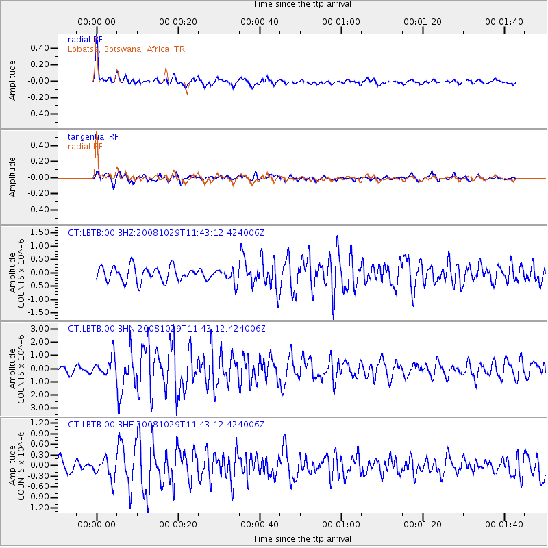
Signal To Noise
| Channel | StoN | STA | LTA |
| GT:LBTB:00:BHN:20081029T11:43:12.424006Z | 3.1629808 | 7.448777E-7 | 2.3549863E-7 |
| GT:LBTB:00:BHE:20081029T11:43:12.424006Z | 1.7485228 | 2.8692844E-7 | 1.6409763E-7 |
| GT:LBTB:00:BHZ:20081029T11:43:12.424006Z | 0.9753568 | 2.6373394E-7 | 2.7039738E-7 |
| Arrivals |
| Ps | 5.1 SECOND |
| PpPs | 17 SECOND |
| PsPs/PpSs | 22 SECOND |


