You are here: Home > Network List > TA - USArray Transportable Network (new EarthScope stations) Stations List
> Station J04D Umpqua National Forest, Toketee, OR, USA > Earthquake Result Viewer
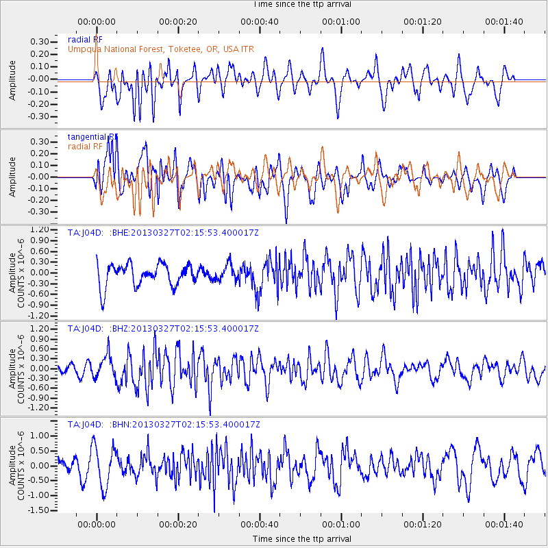
J04D Umpqua National Forest, Toketee, OR, USA - Earthquake Result Viewer
*The percent match for this event was below the threshold and hence no stack was calculated.
| Earthquake location: |
Taiwan |
| Earthquake latitude/longitude: |
23.8/121.2 |
| Earthquake time(UTC): |
2013/03/27 (086) 02:03:19 GMT |
| Earthquake Depth: |
19 km |
| Earthquake Magnitude: |
5.8 MB, 5.8 MS, 5.9 MW, 5.9 MW |
| Earthquake Catalog/Contributor: |
WHDF/NEIC |
|
| Network: |
TA USArray Transportable Network (new EarthScope stations) |
| Station: |
J04D Umpqua National Forest, Toketee, OR, USA |
| Lat/Lon: |
43.24 N/122.11 W |
| Elevation: |
1948 m |
|
| Distance: |
91.5 deg |
| Az: |
40.785 deg |
| Baz: |
305.058 deg |
| Ray Param: |
$rayparam |
*The percent match for this event was below the threshold and hence was not used in the summary stack. |
|
| Radial Match: |
55.979412 % |
| Radial Bump: |
400 |
| Transverse Match: |
59.981705 % |
| Transverse Bump: |
400 |
| SOD ConfigId: |
506627 |
| Insert Time: |
2013-06-07 04:18:09.857 +0000 |
| GWidth: |
2.5 |
| Max Bumps: |
400 |
| Tol: |
0.001 |
|
Signal To Noise
| Channel | StoN | STA | LTA |
| TA:J04D: :BHZ:20130327T02:15:53.400017Z | 1.0426347 | 3.625111E-7 | 3.4768752E-7 |
| TA:J04D: :BHN:20130327T02:15:53.400017Z | 2.993394 | 6.9241054E-7 | 2.3131287E-7 |
| TA:J04D: :BHE:20130327T02:15:53.400017Z | 0.74200135 | 2.2761647E-7 | 3.0676017E-7 |
| Arrivals |
| Ps | |
| PpPs | |
| PsPs/PpSs | |


