You are here: Home > Network List > TA - USArray Transportable Network (new EarthScope stations) Stations List
> Station TOLK Toolik Lake Research Station, AK, USA > Earthquake Result Viewer
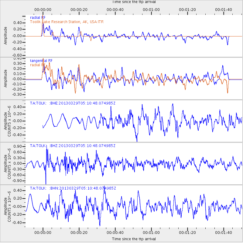
TOLK Toolik Lake Research Station, AK, USA - Earthquake Result Viewer
*The percent match for this event was below the threshold and hence no stack was calculated.
| Earthquake location: |
Northern Xinjiang, China |
| Earthquake latitude/longitude: |
43.5/86.8 |
| Earthquake time(UTC): |
2013/03/29 (088) 05:01:09 GMT |
| Earthquake Depth: |
20 km |
| Earthquake Magnitude: |
5.5 MB, 5.1 MS, 5.2 MW, 5.5 MW |
| Earthquake Catalog/Contributor: |
WHDF/NEIC |
|
| Network: |
TA USArray Transportable Network (new EarthScope stations) |
| Station: |
TOLK Toolik Lake Research Station, AK, USA |
| Lat/Lon: |
68.64 N/149.57 W |
| Elevation: |
760 m |
|
| Distance: |
60.6 deg |
| Az: |
20.497 deg |
| Baz: |
315.891 deg |
| Ray Param: |
$rayparam |
*The percent match for this event was below the threshold and hence was not used in the summary stack. |
|
| Radial Match: |
64.23397 % |
| Radial Bump: |
400 |
| Transverse Match: |
56.420425 % |
| Transverse Bump: |
400 |
| SOD ConfigId: |
506627 |
| Insert Time: |
2013-06-07 04:26:16.478 +0000 |
| GWidth: |
2.5 |
| Max Bumps: |
400 |
| Tol: |
0.001 |
|
Signal To Noise
| Channel | StoN | STA | LTA |
| TA:TOLK: :BHZ:20130329T05:10:48.074985Z | 3.7400103 | 3.53673E-7 | 9.456471E-8 |
| TA:TOLK: :BHN:20130329T05:10:48.074985Z | 0.6969918 | 1.05943236E-7 | 1.520007E-7 |
| TA:TOLK: :BHE:20130329T05:10:48.074985Z | 1.0039043 | 1.2255425E-7 | 1.2207761E-7 |
| Arrivals |
| Ps | |
| PpPs | |
| PsPs/PpSs | |


