You are here: Home > Network List > TA - USArray Transportable Network (new EarthScope stations) Stations List
> Station O48A Farmland, IN, USA > Earthquake Result Viewer
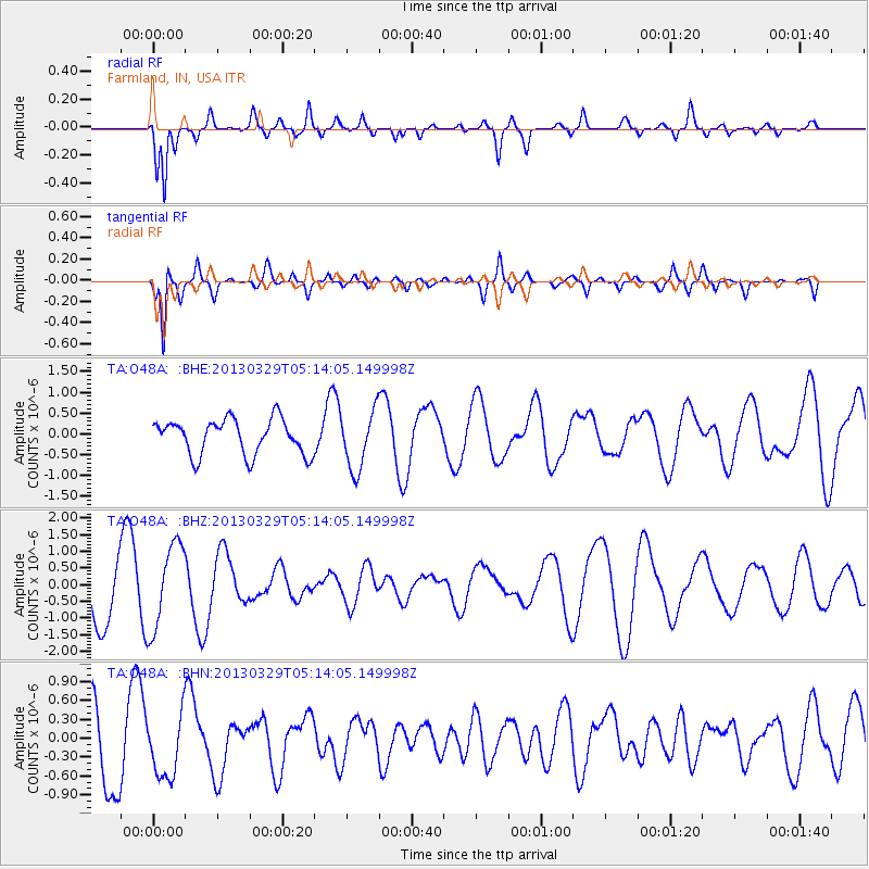
O48A Farmland, IN, USA - Earthquake Result Viewer
*The percent match for this event was below the threshold and hence no stack was calculated.
| Earthquake location: |
Northern Xinjiang, China |
| Earthquake latitude/longitude: |
43.5/86.8 |
| Earthquake time(UTC): |
2013/03/29 (088) 05:01:09 GMT |
| Earthquake Depth: |
20 km |
| Earthquake Magnitude: |
5.5 MB, 5.1 MS, 5.2 MW, 5.5 MW |
| Earthquake Catalog/Contributor: |
WHDF/NEIC |
|
| Network: |
TA USArray Transportable Network (new EarthScope stations) |
| Station: |
O48A Farmland, IN, USA |
| Lat/Lon: |
40.26 N/85.16 W |
| Elevation: |
300 m |
|
| Distance: |
96.4 deg |
| Az: |
353.851 deg |
| Baz: |
5.85 deg |
| Ray Param: |
$rayparam |
*The percent match for this event was below the threshold and hence was not used in the summary stack. |
|
| Radial Match: |
77.31294 % |
| Radial Bump: |
400 |
| Transverse Match: |
83.63079 % |
| Transverse Bump: |
357 |
| SOD ConfigId: |
506627 |
| Insert Time: |
2013-06-07 04:26:43.223 +0000 |
| GWidth: |
2.5 |
| Max Bumps: |
400 |
| Tol: |
0.001 |
|
Signal To Noise
| Channel | StoN | STA | LTA |
| TA:O48A: :BHZ:20130329T05:14:05.149998Z | 1.6124443 | 1.2739226E-6 | 7.900569E-7 |
| TA:O48A: :BHN:20130329T05:14:05.149998Z | 1.0154053 | 4.94831E-7 | 4.873237E-7 |
| TA:O48A: :BHE:20130329T05:14:05.149998Z | 1.658803 | 7.03227E-7 | 4.239364E-7 |
| Arrivals |
| Ps | |
| PpPs | |
| PsPs/PpSs | |


