You are here: Home > Network List > TA - USArray Transportable Network (new EarthScope stations) Stations List
> Station H04D Lebanon, OR, USA > Earthquake Result Viewer
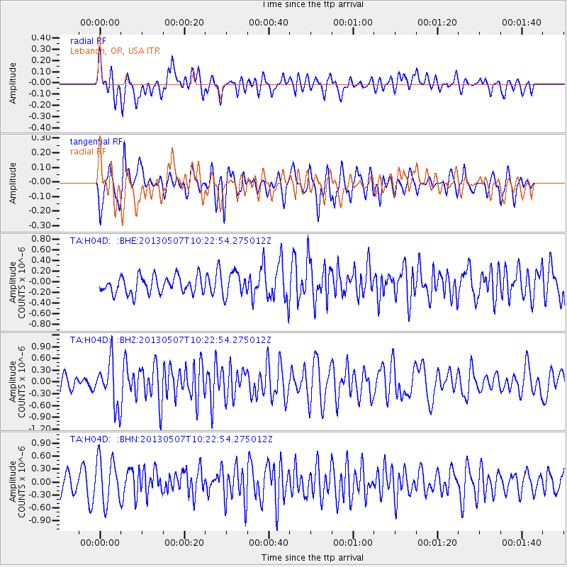
H04D Lebanon, OR, USA - Earthquake Result Viewer
*The percent match for this event was below the threshold and hence no stack was calculated.
| Earthquake location: |
South Of Fiji Islands |
| Earthquake latitude/longitude: |
-19.6/175.1 |
| Earthquake time(UTC): |
2013/05/07 (127) 10:10:48 GMT |
| Earthquake Depth: |
11 km |
| Earthquake Magnitude: |
5.6 MB, 5.7 MS, 6.0 MW, 5.9 MW |
| Earthquake Catalog/Contributor: |
WHDF/NEIC |
|
| Network: |
TA USArray Transportable Network (new EarthScope stations) |
| Station: |
H04D Lebanon, OR, USA |
| Lat/Lon: |
44.52 N/122.74 W |
| Elevation: |
284 m |
|
| Distance: |
85.3 deg |
| Az: |
39.413 deg |
| Baz: |
236.791 deg |
| Ray Param: |
$rayparam |
*The percent match for this event was below the threshold and hence was not used in the summary stack. |
|
| Radial Match: |
64.4871 % |
| Radial Bump: |
400 |
| Transverse Match: |
65.9412 % |
| Transverse Bump: |
400 |
| SOD ConfigId: |
508211 |
| Insert Time: |
2013-07-12 08:25:52.906 +0000 |
| GWidth: |
2.5 |
| Max Bumps: |
400 |
| Tol: |
0.001 |
|
Signal To Noise
| Channel | StoN | STA | LTA |
| TA:H04D: :BHZ:20130507T10:22:54.275012Z | 2.7396846 | 5.869508E-7 | 2.1424027E-7 |
| TA:H04D: :BHN:20130507T10:22:54.275012Z | 2.0187993 | 5.3370513E-7 | 2.6436757E-7 |
| TA:H04D: :BHE:20130507T10:22:54.275012Z | 1.3695749 | 2.1584891E-7 | 1.5760284E-7 |
| Arrivals |
| Ps | |
| PpPs | |
| PsPs/PpSs | |


