You are here: Home > Network List > TA - USArray Transportable Network (new EarthScope stations) Stations List
> Station O03E Paynes Creek, CA, USA > Earthquake Result Viewer
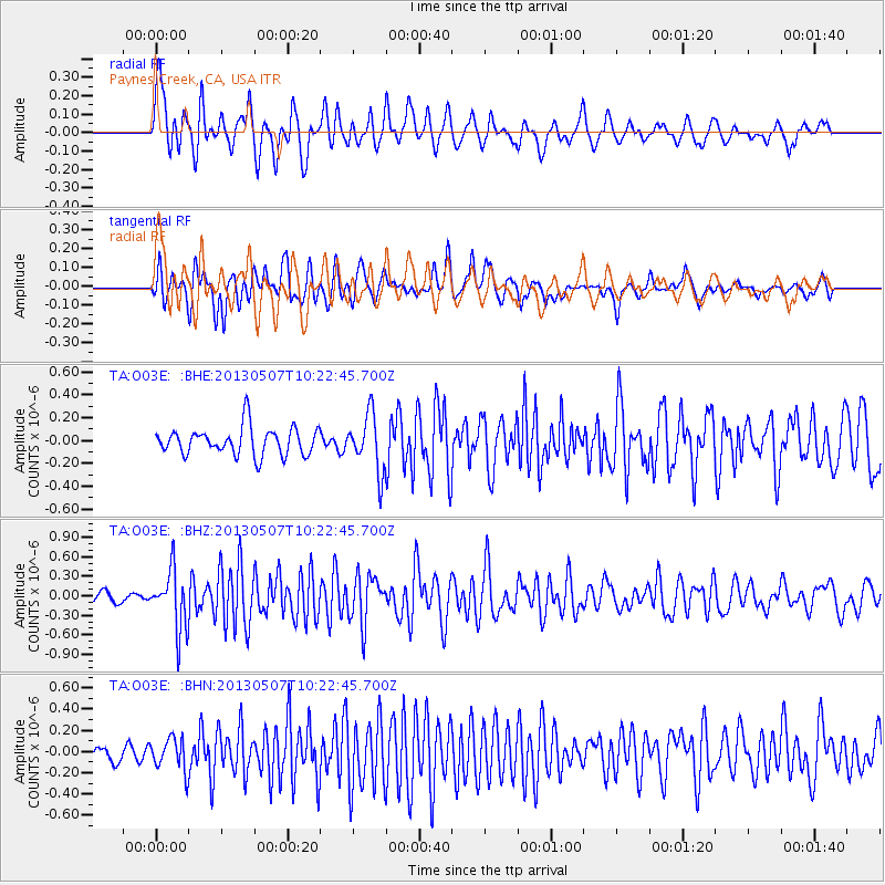
O03E Paynes Creek, CA, USA - Earthquake Result Viewer
*The percent match for this event was below the threshold and hence no stack was calculated.
| Earthquake location: |
South Of Fiji Islands |
| Earthquake latitude/longitude: |
-19.6/175.1 |
| Earthquake time(UTC): |
2013/05/07 (127) 10:10:48 GMT |
| Earthquake Depth: |
11 km |
| Earthquake Magnitude: |
5.6 MB, 5.7 MS, 6.0 MW, 5.9 MW |
| Earthquake Catalog/Contributor: |
WHDF/NEIC |
|
| Network: |
TA USArray Transportable Network (new EarthScope stations) |
| Station: |
O03E Paynes Creek, CA, USA |
| Lat/Lon: |
40.29 N/121.80 W |
| Elevation: |
967 m |
|
| Distance: |
83.6 deg |
| Az: |
43.362 deg |
| Baz: |
237.799 deg |
| Ray Param: |
$rayparam |
*The percent match for this event was below the threshold and hence was not used in the summary stack. |
|
| Radial Match: |
73.098785 % |
| Radial Bump: |
400 |
| Transverse Match: |
76.19478 % |
| Transverse Bump: |
400 |
| SOD ConfigId: |
508211 |
| Insert Time: |
2013-07-12 08:26:33.105 +0000 |
| GWidth: |
2.5 |
| Max Bumps: |
400 |
| Tol: |
0.001 |
|
Signal To Noise
| Channel | StoN | STA | LTA |
| TA:O03E: :BHZ:20130507T10:22:45.700Z | 5.1598105 | 4.513755E-7 | 8.747909E-8 |
| TA:O03E: :BHN:20130507T10:22:45.700Z | 1.7978555 | 1.526879E-7 | 8.492779E-8 |
| TA:O03E: :BHE:20130507T10:22:45.700Z | 2.0487976 | 2.4741115E-7 | 1.2075918E-7 |
| Arrivals |
| Ps | |
| PpPs | |
| PsPs/PpSs | |


