You are here: Home > Network List > TA - USArray Transportable Network (new EarthScope stations) Stations List
> Station J01E Myrtle Point, OR, USA > Earthquake Result Viewer
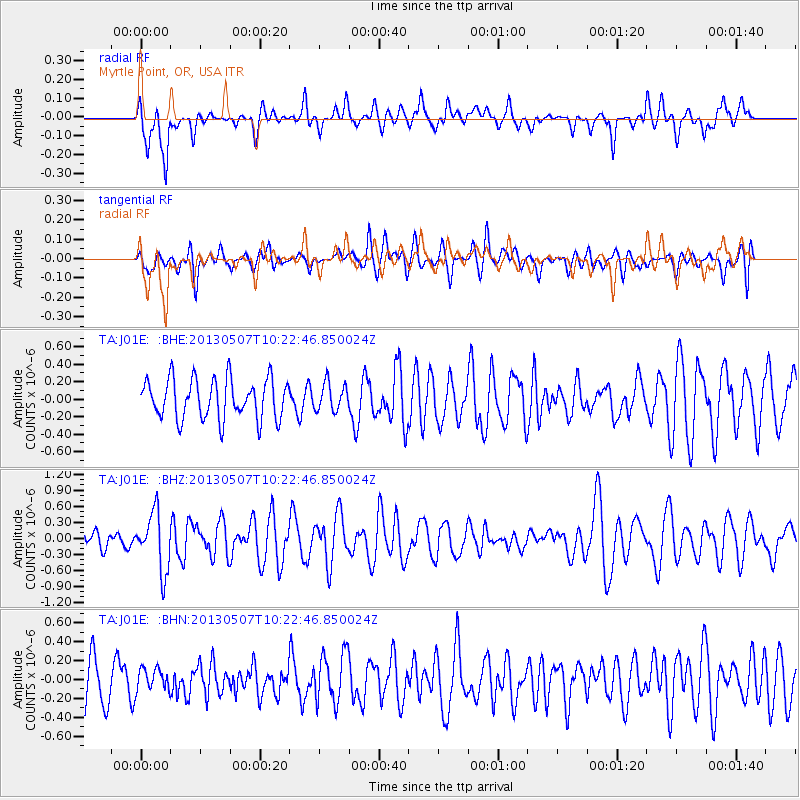
J01E Myrtle Point, OR, USA - Earthquake Result Viewer
*The percent match for this event was below the threshold and hence no stack was calculated.
| Earthquake location: |
South Of Fiji Islands |
| Earthquake latitude/longitude: |
-19.6/175.1 |
| Earthquake time(UTC): |
2013/05/07 (127) 10:10:48 GMT |
| Earthquake Depth: |
11 km |
| Earthquake Magnitude: |
5.6 MB, 5.7 MS, 6.0 MW, 5.9 MW |
| Earthquake Catalog/Contributor: |
WHDF/NEIC |
|
| Network: |
TA USArray Transportable Network (new EarthScope stations) |
| Station: |
J01E Myrtle Point, OR, USA |
| Lat/Lon: |
43.16 N/123.93 W |
| Elevation: |
128 m |
|
| Distance: |
83.9 deg |
| Az: |
40.072 deg |
| Baz: |
236.029 deg |
| Ray Param: |
$rayparam |
*The percent match for this event was below the threshold and hence was not used in the summary stack. |
|
| Radial Match: |
51.77229 % |
| Radial Bump: |
400 |
| Transverse Match: |
55.433277 % |
| Transverse Bump: |
400 |
| SOD ConfigId: |
508211 |
| Insert Time: |
2013-07-12 08:26:44.382 +0000 |
| GWidth: |
2.5 |
| Max Bumps: |
400 |
| Tol: |
0.001 |
|
Signal To Noise
| Channel | StoN | STA | LTA |
| TA:J01E: :BHZ:20130507T10:22:46.850024Z | 2.1639729 | 5.4194703E-7 | 2.5044076E-7 |
| TA:J01E: :BHN:20130507T10:22:46.850024Z | 0.41445696 | 1.15463685E-7 | 2.7859028E-7 |
| TA:J01E: :BHE:20130507T10:22:46.850024Z | 0.69288594 | 1.5808111E-7 | 2.2814882E-7 |
| Arrivals |
| Ps | |
| PpPs | |
| PsPs/PpSs | |


