You are here: Home > Network List > TA - USArray Transportable Network (new EarthScope stations) Stations List
> Station 352A Blakely, GA, USA > Earthquake Result Viewer
352A Blakely, GA, USA - Earthquake Result Viewer
*The percent match for this event was below the threshold and hence no stack was calculated.
| Earthquake location: |
Southern Mid-Atlantic Ridge |
| Earthquake latitude/longitude: |
-29.0/-13.2 |
| Earthquake time(UTC): |
2013/05/10 (130) 19:56:04 GMT |
| Earthquake Depth: |
3.9 km |
| Earthquake Magnitude: |
5.5 MB, 5.6 MS, 5.7 MW, 5.7 MW |
| Earthquake Catalog/Contributor: |
WHDF/NEIC |
|
| Network: |
TA USArray Transportable Network (new EarthScope stations) |
| Station: |
352A Blakely, GA, USA |
| Lat/Lon: |
31.48 N/84.93 W |
| Elevation: |
101 m |
|
| Distance: |
90.9 deg |
| Az: |
305.78 deg |
| Baz: |
123.704 deg |
| Ray Param: |
$rayparam |
*The percent match for this event was below the threshold and hence was not used in the summary stack. |
|
| Radial Match: |
47.265347 % |
| Radial Bump: |
400 |
| Transverse Match: |
36.622555 % |
| Transverse Bump: |
400 |
| SOD ConfigId: |
508211 |
| Insert Time: |
2013-07-12 08:35:06.402 +0000 |
| GWidth: |
2.5 |
| Max Bumps: |
400 |
| Tol: |
0.001 |
|
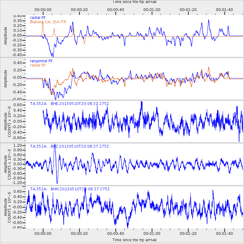
Signal To Noise
| Channel | StoN | STA | LTA |
| TA:352A: :BHZ:20130510T20:08:37.275Z | 1.5390258 | 2.4188932E-7 | 1.5717042E-7 |
| TA:352A: :BHN:20130510T20:08:37.275Z | 1.0239828 | 3.4822557E-7 | 3.4006976E-7 |
| TA:352A: :BHE:20130510T20:08:37.275Z | 1.1760381 | 2.1061902E-7 | 1.7909198E-7 |
| Arrivals |
| Ps | |
| PpPs | |
| PsPs/PpSs | |


