You are here: Home > Network List > CI - Caltech Regional Seismic Network Stations List
> Station MUR Murrieta > Earthquake Result Viewer
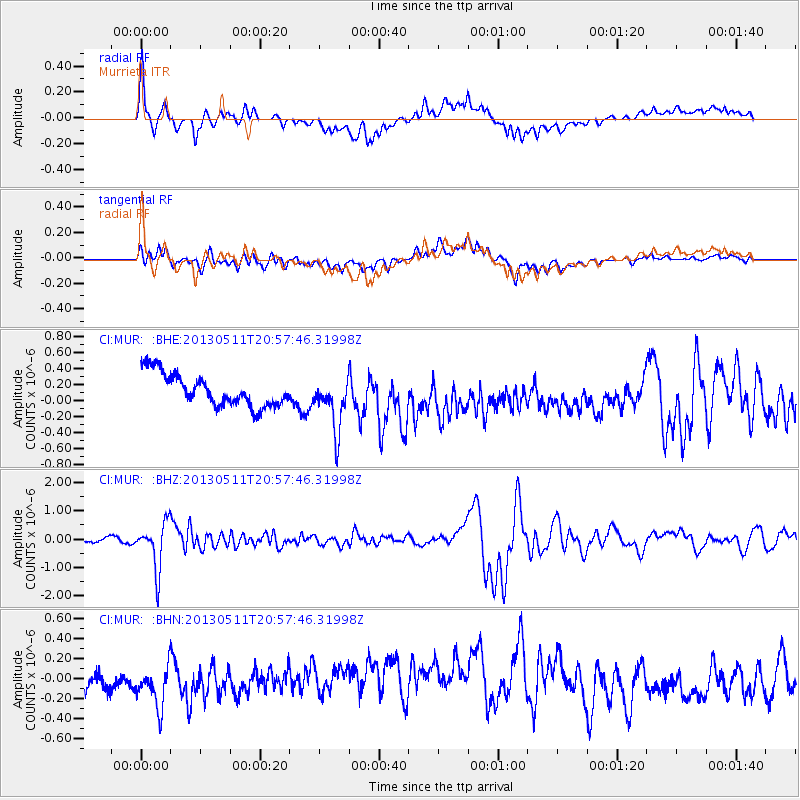
MUR Murrieta - Earthquake Result Viewer
*The percent match for this event was below the threshold and hence no stack was calculated.
| Earthquake location: |
Tonga Islands |
| Earthquake latitude/longitude: |
-18.0/-175.1 |
| Earthquake time(UTC): |
2013/05/11 (131) 20:46:57 GMT |
| Earthquake Depth: |
213 km |
| Earthquake Magnitude: |
5.8 MB, 6.4 MW, 6.4 MW |
| Earthquake Catalog/Contributor: |
WHDF/NEIC |
|
| Network: |
CI Caltech Regional Seismic Network |
| Station: |
MUR Murrieta |
| Lat/Lon: |
33.60 N/117.20 W |
| Elevation: |
562 m |
|
| Distance: |
75.3 deg |
| Az: |
46.965 deg |
| Baz: |
236.469 deg |
| Ray Param: |
$rayparam |
*The percent match for this event was below the threshold and hence was not used in the summary stack. |
|
| Radial Match: |
74.08743 % |
| Radial Bump: |
400 |
| Transverse Match: |
62.92674 % |
| Transverse Bump: |
400 |
| SOD ConfigId: |
508211 |
| Insert Time: |
2013-07-12 08:56:03.610 +0000 |
| GWidth: |
2.5 |
| Max Bumps: |
400 |
| Tol: |
0.001 |
|
Signal To Noise
| Channel | StoN | STA | LTA |
| CI:MUR: :BHZ:20130511T20:57:46.31998Z | 9.390036 | 8.194963E-7 | 8.7272966E-8 |
| CI:MUR: :BHN:20130511T20:57:46.31998Z | 2.7135904 | 2.0611337E-7 | 7.595597E-8 |
| CI:MUR: :BHE:20130511T20:57:46.31998Z | 1.6399012 | 3.2766687E-7 | 1.9980892E-7 |
| Arrivals |
| Ps | |
| PpPs | |
| PsPs/PpSs | |


