You are here: Home > Network List > TA - USArray Transportable Network (new EarthScope stations) Stations List
> Station MDND Maddock, ND, USA > Earthquake Result Viewer
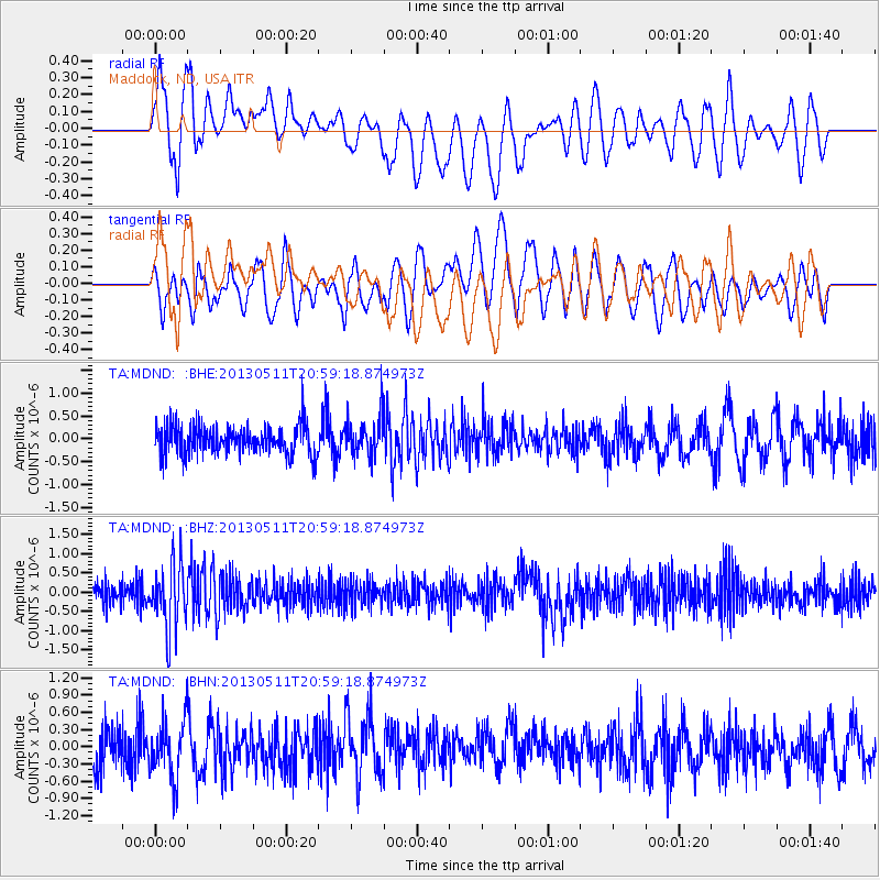
MDND Maddock, ND, USA - Earthquake Result Viewer
*The percent match for this event was below the threshold and hence no stack was calculated.
| Earthquake location: |
Tonga Islands |
| Earthquake latitude/longitude: |
-18.0/-175.1 |
| Earthquake time(UTC): |
2013/05/11 (131) 20:46:57 GMT |
| Earthquake Depth: |
213 km |
| Earthquake Magnitude: |
5.8 MB, 6.4 MW, 6.4 MW |
| Earthquake Catalog/Contributor: |
WHDF/NEIC |
|
| Network: |
TA USArray Transportable Network (new EarthScope stations) |
| Station: |
MDND Maddock, ND, USA |
| Lat/Lon: |
47.85 N/99.60 W |
| Elevation: |
479 m |
|
| Distance: |
93.8 deg |
| Az: |
40.811 deg |
| Baz: |
247.453 deg |
| Ray Param: |
$rayparam |
*The percent match for this event was below the threshold and hence was not used in the summary stack. |
|
| Radial Match: |
68.31942 % |
| Radial Bump: |
400 |
| Transverse Match: |
58.13731 % |
| Transverse Bump: |
400 |
| SOD ConfigId: |
508211 |
| Insert Time: |
2013-07-12 09:01:45.182 +0000 |
| GWidth: |
2.5 |
| Max Bumps: |
400 |
| Tol: |
0.001 |
|
Signal To Noise
| Channel | StoN | STA | LTA |
| TA:MDND: :BHZ:20130511T20:59:18.874973Z | 2.6604702 | 8.4717357E-7 | 3.1843004E-7 |
| TA:MDND: :BHN:20130511T20:59:18.874973Z | 1.4242791 | 5.0215004E-7 | 3.5256437E-7 |
| TA:MDND: :BHE:20130511T20:59:18.874973Z | 1.3078775 | 4.1618938E-7 | 3.182174E-7 |
| Arrivals |
| Ps | |
| PpPs | |
| PsPs/PpSs | |


