You are here: Home > Network List > TA - USArray Transportable Network (new EarthScope stations) Stations List
> Station G05D Wamic, OR, USA > Earthquake Result Viewer
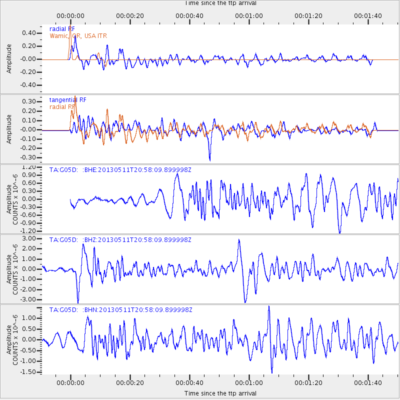
G05D Wamic, OR, USA - Earthquake Result Viewer
*The percent match for this event was below the threshold and hence no stack was calculated.
| Earthquake location: |
Tonga Islands |
| Earthquake latitude/longitude: |
-18.0/-175.1 |
| Earthquake time(UTC): |
2013/05/11 (131) 20:46:57 GMT |
| Earthquake Depth: |
213 km |
| Earthquake Magnitude: |
5.8 MB, 6.4 MW, 6.4 MW |
| Earthquake Catalog/Contributor: |
WHDF/NEIC |
|
| Network: |
TA USArray Transportable Network (new EarthScope stations) |
| Station: |
G05D Wamic, OR, USA |
| Lat/Lon: |
45.24 N/121.32 W |
| Elevation: |
592 m |
|
| Distance: |
79.6 deg |
| Az: |
35.418 deg |
| Baz: |
231.334 deg |
| Ray Param: |
$rayparam |
*The percent match for this event was below the threshold and hence was not used in the summary stack. |
|
| Radial Match: |
69.062035 % |
| Radial Bump: |
400 |
| Transverse Match: |
76.313705 % |
| Transverse Bump: |
400 |
| SOD ConfigId: |
508211 |
| Insert Time: |
2013-07-12 09:02:27.003 +0000 |
| GWidth: |
2.5 |
| Max Bumps: |
400 |
| Tol: |
0.001 |
|
Signal To Noise
| Channel | StoN | STA | LTA |
| TA:G05D: :BHZ:20130511T20:58:09.899998Z | 6.195886 | 1.3847069E-6 | 2.2348812E-7 |
| TA:G05D: :BHN:20130511T20:58:09.899998Z | 1.7240453 | 3.3372277E-7 | 1.9356962E-7 |
| TA:G05D: :BHE:20130511T20:58:09.899998Z | 3.7551265 | 3.9078864E-7 | 1.0406804E-7 |
| Arrivals |
| Ps | |
| PpPs | |
| PsPs/PpSs | |


