You are here: Home > Network List > TA - USArray Transportable Network (new EarthScope stations) Stations List
> Station A04D Lummi Island, WA, USA > Earthquake Result Viewer
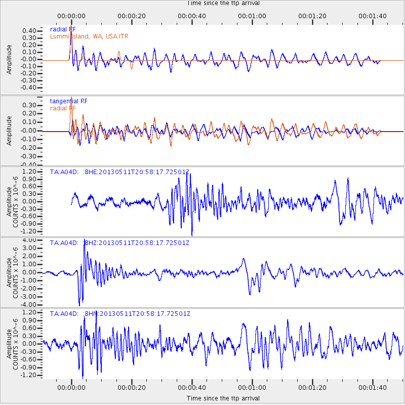
A04D Lummi Island, WA, USA - Earthquake Result Viewer
*The percent match for this event was below the threshold and hence no stack was calculated.
| Earthquake location: |
Tonga Islands |
| Earthquake latitude/longitude: |
-18.0/-175.1 |
| Earthquake time(UTC): |
2013/05/11 (131) 20:46:57 GMT |
| Earthquake Depth: |
213 km |
| Earthquake Magnitude: |
5.8 MB, 6.4 MW, 6.4 MW |
| Earthquake Catalog/Contributor: |
WHDF/NEIC |
|
| Network: |
TA USArray Transportable Network (new EarthScope stations) |
| Station: |
A04D Lummi Island, WA, USA |
| Lat/Lon: |
48.72 N/122.71 W |
| Elevation: |
13 m |
|
| Distance: |
81.1 deg |
| Az: |
32.08 deg |
| Baz: |
229.761 deg |
| Ray Param: |
$rayparam |
*The percent match for this event was below the threshold and hence was not used in the summary stack. |
|
| Radial Match: |
71.11321 % |
| Radial Bump: |
400 |
| Transverse Match: |
64.08475 % |
| Transverse Bump: |
400 |
| SOD ConfigId: |
508211 |
| Insert Time: |
2013-07-12 09:03:56.561 +0000 |
| GWidth: |
2.5 |
| Max Bumps: |
400 |
| Tol: |
0.001 |
|
Signal To Noise
| Channel | StoN | STA | LTA |
| TA:A04D: :BHZ:20130511T20:58:17.72501Z | 10.46781 | 1.6919491E-6 | 1.6163354E-7 |
| TA:A04D: :BHN:20130511T20:58:17.72501Z | 2.9516459 | 4.7344457E-7 | 1.604002E-7 |
| TA:A04D: :BHE:20130511T20:58:17.72501Z | 3.0413554 | 4.0732496E-7 | 1.3392876E-7 |
| Arrivals |
| Ps | |
| PpPs | |
| PsPs/PpSs | |


