You are here: Home > Network List > TA - USArray Transportable Network (new EarthScope stations) Stations List
> Station W39A Magazine, AR, USA > Earthquake Result Viewer
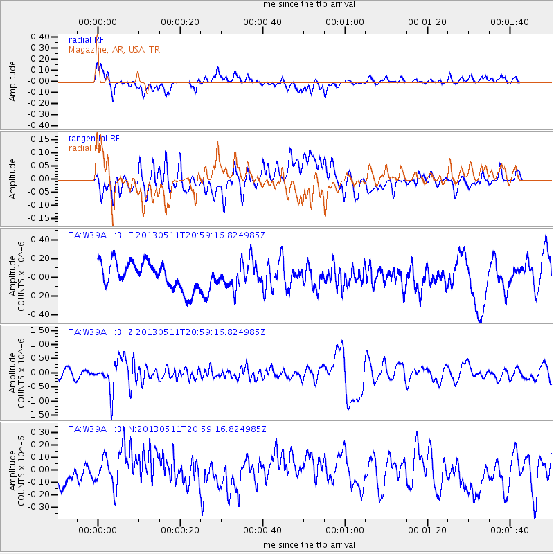
W39A Magazine, AR, USA - Earthquake Result Viewer
*The percent match for this event was below the threshold and hence no stack was calculated.
| Earthquake location: |
Tonga Islands |
| Earthquake latitude/longitude: |
-18.0/-175.1 |
| Earthquake time(UTC): |
2013/05/11 (131) 20:46:57 GMT |
| Earthquake Depth: |
213 km |
| Earthquake Magnitude: |
5.8 MB, 6.4 MW, 6.4 MW |
| Earthquake Catalog/Contributor: |
WHDF/NEIC |
|
| Network: |
TA USArray Transportable Network (new EarthScope stations) |
| Station: |
W39A Magazine, AR, USA |
| Lat/Lon: |
35.20 N/93.78 W |
| Elevation: |
162 m |
|
| Distance: |
93.3 deg |
| Az: |
54.195 deg |
| Baz: |
250.486 deg |
| Ray Param: |
$rayparam |
*The percent match for this event was below the threshold and hence was not used in the summary stack. |
|
| Radial Match: |
67.60832 % |
| Radial Bump: |
400 |
| Transverse Match: |
52.099373 % |
| Transverse Bump: |
400 |
| SOD ConfigId: |
508211 |
| Insert Time: |
2013-07-12 09:04:23.719 +0000 |
| GWidth: |
2.5 |
| Max Bumps: |
400 |
| Tol: |
0.001 |
|
Signal To Noise
| Channel | StoN | STA | LTA |
| TA:W39A: :BHZ:20130511T20:59:16.824985Z | 3.8453584 | 4.9589175E-7 | 1.2895853E-7 |
| TA:W39A: :BHN:20130511T20:59:16.824985Z | 0.9018287 | 1.18008394E-7 | 1.3085456E-7 |
| TA:W39A: :BHE:20130511T20:59:16.824985Z | 0.8360415 | 1.1961593E-7 | 1.4307416E-7 |
| Arrivals |
| Ps | |
| PpPs | |
| PsPs/PpSs | |


