You are here: Home > Network List > TA - USArray Transportable Network (new EarthScope stations) Stations List
> Station Z41A Richland Creek Farm, El Dorado, AR, USA > Earthquake Result Viewer
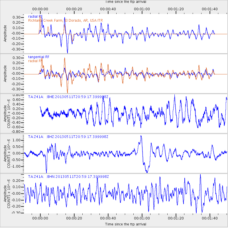
Z41A Richland Creek Farm, El Dorado, AR, USA - Earthquake Result Viewer
*The percent match for this event was below the threshold and hence no stack was calculated.
| Earthquake location: |
Tonga Islands |
| Earthquake latitude/longitude: |
-18.0/-175.1 |
| Earthquake time(UTC): |
2013/05/11 (131) 20:46:57 GMT |
| Earthquake Depth: |
213 km |
| Earthquake Magnitude: |
5.8 MB, 6.4 MW, 6.4 MW |
| Earthquake Catalog/Contributor: |
WHDF/NEIC |
|
| Network: |
TA USArray Transportable Network (new EarthScope stations) |
| Station: |
Z41A Richland Creek Farm, El Dorado, AR, USA |
| Lat/Lon: |
33.26 N/92.80 W |
| Elevation: |
62 m |
|
| Distance: |
93.5 deg |
| Az: |
56.292 deg |
| Baz: |
250.91 deg |
| Ray Param: |
$rayparam |
*The percent match for this event was below the threshold and hence was not used in the summary stack. |
|
| Radial Match: |
65.34335 % |
| Radial Bump: |
400 |
| Transverse Match: |
58.795815 % |
| Transverse Bump: |
400 |
| SOD ConfigId: |
508211 |
| Insert Time: |
2013-07-12 09:04:29.380 +0000 |
| GWidth: |
2.5 |
| Max Bumps: |
400 |
| Tol: |
0.001 |
|
Signal To Noise
| Channel | StoN | STA | LTA |
| TA:Z41A: :BHZ:20130511T20:59:17.399998Z | 4.005645 | 4.4319466E-7 | 1.10642524E-7 |
| TA:Z41A: :BHN:20130511T20:59:17.399998Z | 0.88706464 | 8.199859E-8 | 9.2438135E-8 |
| TA:Z41A: :BHE:20130511T20:59:17.399998Z | 2.7002904 | 2.988497E-7 | 1.1067316E-7 |
| Arrivals |
| Ps | |
| PpPs | |
| PsPs/PpSs | |


