You are here: Home > Network List > TA - USArray Transportable Network (new EarthScope stations) Stations List
> Station X46A Booneville, MS, USA > Earthquake Result Viewer
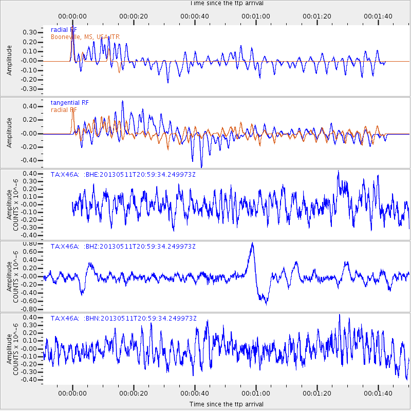
X46A Booneville, MS, USA - Earthquake Result Viewer
*The percent match for this event was below the threshold and hence no stack was calculated.
| Earthquake location: |
Tonga Islands |
| Earthquake latitude/longitude: |
-18.0/-175.1 |
| Earthquake time(UTC): |
2013/05/11 (131) 20:46:57 GMT |
| Earthquake Depth: |
213 km |
| Earthquake Magnitude: |
5.8 MB, 6.4 MW, 6.4 MW |
| Earthquake Catalog/Contributor: |
WHDF/NEIC |
|
| Network: |
TA USArray Transportable Network (new EarthScope stations) |
| Station: |
X46A Booneville, MS, USA |
| Lat/Lon: |
34.56 N/88.58 W |
| Elevation: |
150 m |
|
| Distance: |
97.2 deg |
| Az: |
56.138 deg |
| Baz: |
253.268 deg |
| Ray Param: |
$rayparam |
*The percent match for this event was below the threshold and hence was not used in the summary stack. |
|
| Radial Match: |
49.148643 % |
| Radial Bump: |
400 |
| Transverse Match: |
50.05113 % |
| Transverse Bump: |
400 |
| SOD ConfigId: |
508211 |
| Insert Time: |
2013-07-12 09:05:49.724 +0000 |
| GWidth: |
2.5 |
| Max Bumps: |
400 |
| Tol: |
0.001 |
|
Signal To Noise
| Channel | StoN | STA | LTA |
| TA:X46A: :BHZ:20130511T20:59:34.249973Z | 3.1286306 | 1.889419E-7 | 6.0391244E-8 |
| TA:X46A: :BHN:20130511T20:59:34.249973Z | 0.8213835 | 9.121126E-8 | 1.1104589E-7 |
| TA:X46A: :BHE:20130511T20:59:34.249973Z | 1.2260153 | 1.3888963E-7 | 1.13285395E-7 |
| Arrivals |
| Ps | |
| PpPs | |
| PsPs/PpSs | |


