You are here: Home > Network List > TA - USArray Transportable Network (new EarthScope stations) Stations List
> Station J01E Myrtle Point, OR, USA > Earthquake Result Viewer
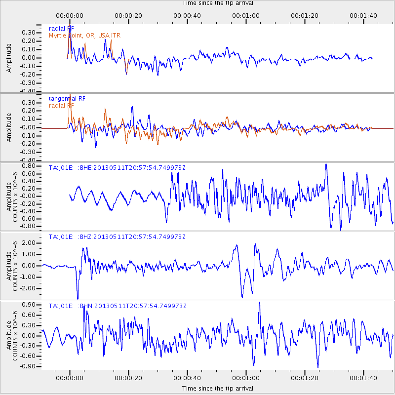
J01E Myrtle Point, OR, USA - Earthquake Result Viewer
*The percent match for this event was below the threshold and hence no stack was calculated.
| Earthquake location: |
Tonga Islands |
| Earthquake latitude/longitude: |
-18.0/-175.1 |
| Earthquake time(UTC): |
2013/05/11 (131) 20:46:57 GMT |
| Earthquake Depth: |
213 km |
| Earthquake Magnitude: |
5.8 MB, 6.4 MW, 6.4 MW |
| Earthquake Catalog/Contributor: |
WHDF/NEIC |
|
| Network: |
TA USArray Transportable Network (new EarthScope stations) |
| Station: |
J01E Myrtle Point, OR, USA |
| Lat/Lon: |
43.16 N/123.93 W |
| Elevation: |
128 m |
|
| Distance: |
76.8 deg |
| Az: |
35.834 deg |
| Baz: |
229.602 deg |
| Ray Param: |
$rayparam |
*The percent match for this event was below the threshold and hence was not used in the summary stack. |
|
| Radial Match: |
73.753784 % |
| Radial Bump: |
400 |
| Transverse Match: |
70.214195 % |
| Transverse Bump: |
400 |
| SOD ConfigId: |
508211 |
| Insert Time: |
2013-07-12 09:06:35.699 +0000 |
| GWidth: |
2.5 |
| Max Bumps: |
400 |
| Tol: |
0.001 |
|
Signal To Noise
| Channel | StoN | STA | LTA |
| TA:J01E: :BHZ:20130511T20:57:54.749973Z | 9.768763 | 1.0323452E-6 | 1.0567819E-7 |
| TA:J01E: :BHN:20130511T20:57:54.749973Z | 2.3695993 | 2.4276096E-7 | 1.02448105E-7 |
| TA:J01E: :BHE:20130511T20:57:54.749973Z | 1.8947778 | 2.6924482E-7 | 1.4209837E-7 |
| Arrivals |
| Ps | |
| PpPs | |
| PsPs/PpSs | |


