You are here: Home > Network List > UO - University of Oregon Regional Network Stations List
> Station BUCK Buck Mountain, OR > Earthquake Result Viewer
BUCK Buck Mountain, OR - Earthquake Result Viewer
| Earthquake location: |
Tonga Islands |
| Earthquake latitude/longitude: |
-18.0/-175.1 |
| Earthquake time(UTC): |
2013/05/11 (131) 20:46:57 GMT |
| Earthquake Depth: |
213 km |
| Earthquake Magnitude: |
5.8 MB, 6.4 MW, 6.4 MW |
| Earthquake Catalog/Contributor: |
WHDF/NEIC |
|
| Network: |
UO University of Oregon Regional Network |
| Station: |
BUCK Buck Mountain, OR |
| Lat/Lon: |
44.20 N/122.99 W |
| Elevation: |
964 m |
|
| Distance: |
78.0 deg |
| Az: |
35.475 deg |
| Baz: |
230.175 deg |
| Ray Param: |
0.049372762 |
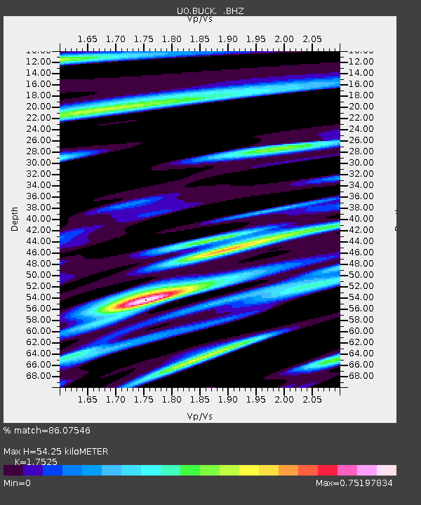
| Estimated Moho Depth: |
54.25 km |
| Estimated Crust Vp/Vs: |
1.75 |
| Assumed Crust Vp: |
6.566 km/s |
| Estimated Crust Vs: |
3.747 km/s |
| Estimated Crust Poisson's Ratio: |
0.26 |
|
| Radial Match: |
86.07546 % |
| Radial Bump: |
400 |
| Transverse Match: |
69.40158 % |
| Transverse Bump: |
400 |
| SOD ConfigId: |
508211 |
| Insert Time: |
2013-07-12 09:07:21.668 +0000 |
| GWidth: |
2.5 |
| Max Bumps: |
400 |
| Tol: |
0.001 |
|

Signal To Noise
| Channel | StoN | STA | LTA |
| UO:BUCK: :BHZ:20130511T20:58:01.32999Z | 15.608058 | 1.2068455E-6 | 7.732194E-8 |
| UO:BUCK: :BHN:20130511T20:58:01.32999Z | 2.5005898 | 3.4554327E-7 | 1.381847E-7 |
| UO:BUCK: :BHE:20130511T20:58:01.32999Z | 1.9888178 | 2.505808E-7 | 1.2599483E-7 |
| Arrivals |
| Ps | 6.4 SECOND |
| PpPs | 22 SECOND |
| PsPs/PpSs | 28 SECOND |


