You are here: Home > Network List > BK - Berkeley Digital Seismograph Network Stations List
> Station SAO San Andreas Geophysical Obs., Hollister, CA, USA > Earthquake Result Viewer
SAO San Andreas Geophysical Obs., Hollister, CA, USA - Earthquake Result Viewer
| Earthquake location: |
Near Coast Of Guatemala |
| Earthquake latitude/longitude: |
13.5/-91.4 |
| Earthquake time(UTC): |
2013/05/12 (132) 07:29:59 GMT |
| Earthquake Depth: |
11 km |
| Earthquake Magnitude: |
5.5 MS, 5.2 MB, 5.8 MW, 5.6 MW |
| Earthquake Catalog/Contributor: |
WHDF/NEIC |
|
| Network: |
BK Berkeley Digital Seismograph Network |
| Station: |
SAO San Andreas Geophysical Obs., Hollister, CA, USA |
| Lat/Lon: |
36.76 N/121.45 W |
| Elevation: |
317 m |
|
| Distance: |
35.5 deg |
| Az: |
316.147 deg |
| Baz: |
122.934 deg |
| Ray Param: |
0.07718433 |
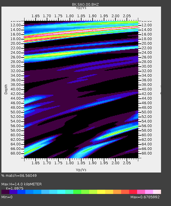
| Estimated Moho Depth: |
14.0 km |
| Estimated Crust Vp/Vs: |
1.90 |
| Assumed Crust Vp: |
6.391 km/s |
| Estimated Crust Vs: |
3.368 km/s |
| Estimated Crust Poisson's Ratio: |
0.31 |
|
| Radial Match: |
86.56049 % |
| Radial Bump: |
400 |
| Transverse Match: |
74.504745 % |
| Transverse Bump: |
400 |
| SOD ConfigId: |
508211 |
| Insert Time: |
2013-07-12 09:17:44.078 +0000 |
| GWidth: |
2.5 |
| Max Bumps: |
400 |
| Tol: |
0.001 |
|
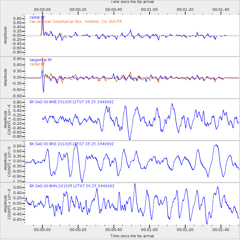
Signal To Noise
| Channel | StoN | STA | LTA |
| BK:SAO:00:BHZ:20130512T07:36:25.344999Z | 5.0270095 | 4.0280523E-7 | 8.0128196E-8 |
| BK:SAO:00:BHN:20130512T07:36:25.344999Z | 1.230197 | 1.5442373E-7 | 1.2552765E-7 |
| BK:SAO:00:BHE:20130512T07:36:25.344999Z | 2.3165748 | 2.562775E-7 | 1.10627774E-7 |
| Arrivals |
| Ps | 2.1 SECOND |
| PpPs | 5.9 SECOND |
| PsPs/PpSs | 8.0 SECOND |


