You are here: Home > Network List > LD - Lamont-Doherty Cooperative Seismographic Network Stations List
> Station HCNY Howe Caverns, Cobleskill, NY > Earthquake Result Viewer
HCNY Howe Caverns, Cobleskill, NY - Earthquake Result Viewer
| Earthquake location: |
Near Coast Of Guatemala |
| Earthquake latitude/longitude: |
13.5/-91.4 |
| Earthquake time(UTC): |
2013/05/12 (132) 07:29:59 GMT |
| Earthquake Depth: |
11 km |
| Earthquake Magnitude: |
5.5 MS, 5.2 MB, 5.8 MW, 5.6 MW |
| Earthquake Catalog/Contributor: |
WHDF/NEIC |
|
| Network: |
LD Lamont-Doherty Cooperative Seismographic Network |
| Station: |
HCNY Howe Caverns, Cobleskill, NY |
| Lat/Lon: |
42.70 N/74.40 W |
| Elevation: |
273 m |
|
| Distance: |
32.6 deg |
| Az: |
23.545 deg |
| Baz: |
211.812 deg |
| Ray Param: |
0.078577645 |
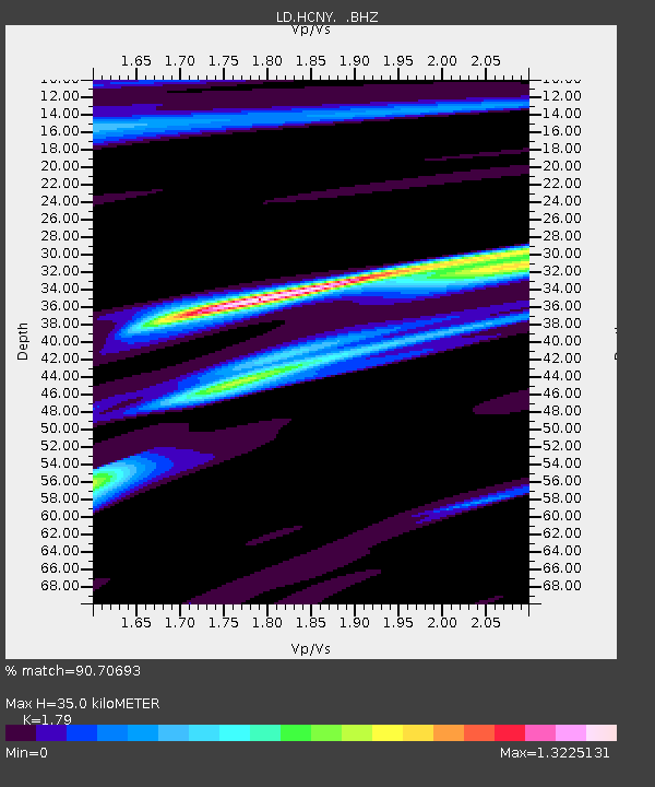
| Estimated Moho Depth: |
35.0 km |
| Estimated Crust Vp/Vs: |
1.79 |
| Assumed Crust Vp: |
6.419 km/s |
| Estimated Crust Vs: |
3.586 km/s |
| Estimated Crust Poisson's Ratio: |
0.27 |
|
| Radial Match: |
90.70693 % |
| Radial Bump: |
336 |
| Transverse Match: |
57.060085 % |
| Transverse Bump: |
400 |
| SOD ConfigId: |
508211 |
| Insert Time: |
2013-07-12 09:23:24.952 +0000 |
| GWidth: |
2.5 |
| Max Bumps: |
400 |
| Tol: |
0.001 |
|

Signal To Noise
| Channel | StoN | STA | LTA |
| LD:HCNY: :BHZ:20130512T07:36:00.230009Z | 3.8012755 | 6.2265616E-7 | 1.638019E-7 |
| LD:HCNY: :BHN:20130512T07:36:00.230009Z | 2.22301 | 3.201146E-7 | 1.4400051E-7 |
| LD:HCNY: :BHE:20130512T07:36:00.230009Z | 2.0470104 | 2.7480132E-7 | 1.342452E-7 |
| Arrivals |
| Ps | 4.7 SECOND |
| PpPs | 14 SECOND |
| PsPs/PpSs | 19 SECOND |


