You are here: Home > Network List > CN - Canadian National Seismograph Network Stations List
> Station INK INUVIK, NT > Earthquake Result Viewer
INK INUVIK, NT - Earthquake Result Viewer
*The percent match for this event was below the threshold and hence no stack was calculated.
| Earthquake location: |
Northeast Of Taiwan |
| Earthquake latitude/longitude: |
26.3/125.8 |
| Earthquake time(UTC): |
2014/07/11 (192) 13:11:45 GMT |
| Earthquake Depth: |
116 km |
| Earthquake Magnitude: |
5.3 MW, 5.3 mb, 5.3 Mwb |
| Earthquake Catalog/Contributor: |
ISC/ISC |
|
| Network: |
CN Canadian National Seismograph Network |
| Station: |
INK INUVIK, NT |
| Lat/Lon: |
68.31 N/133.53 W |
| Elevation: |
44 m |
|
| Distance: |
69.7 deg |
| Az: |
22.935 deg |
| Baz: |
289.815 deg |
| Ray Param: |
$rayparam |
*The percent match for this event was below the threshold and hence was not used in the summary stack. |
|
| Radial Match: |
45.138256 % |
| Radial Bump: |
400 |
| Transverse Match: |
63.659805 % |
| Transverse Bump: |
400 |
| SOD ConfigId: |
3390531 |
| Insert Time: |
2019-04-12 19:24:15.964 +0000 |
| GWidth: |
2.5 |
| Max Bumps: |
400 |
| Tol: |
0.001 |
|
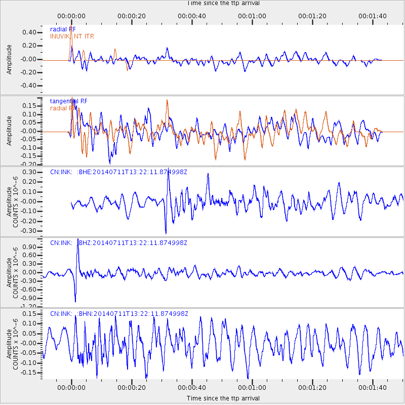
Signal To Noise
| Channel | StoN | STA | LTA |
| CN:INK: :BHZ:20140711T13:22:11.874998Z | 5.846352 | 4.217051E-7 | 7.213132E-8 |
| CN:INK: :BHN:20140711T13:22:11.874998Z | 1.2485579 | 7.235357E-8 | 5.7949713E-8 |
| CN:INK: :BHE:20140711T13:22:11.874998Z | 2.6914723 | 1.4394149E-7 | 5.3480576E-8 |
| Arrivals |
| Ps | |
| PpPs | |
| PsPs/PpSs | |


