You are here: Home > Network List > TA - USArray Transportable Network (new EarthScope stations) Stations List
> Station H41A Junction City, WI, USA > Earthquake Result Viewer
H41A Junction City, WI, USA - Earthquake Result Viewer
| Earthquake location: |
Near Coast Of Guatemala |
| Earthquake latitude/longitude: |
13.5/-91.4 |
| Earthquake time(UTC): |
2013/05/12 (132) 07:29:59 GMT |
| Earthquake Depth: |
11 km |
| Earthquake Magnitude: |
5.5 MS, 5.2 MB, 5.8 MW, 5.6 MW |
| Earthquake Catalog/Contributor: |
WHDF/NEIC |
|
| Network: |
TA USArray Transportable Network (new EarthScope stations) |
| Station: |
H41A Junction City, WI, USA |
| Lat/Lon: |
44.62 N/89.65 W |
| Elevation: |
348 m |
|
| Distance: |
31.1 deg |
| Az: |
2.384 deg |
| Baz: |
183.248 deg |
| Ray Param: |
0.07916485 |
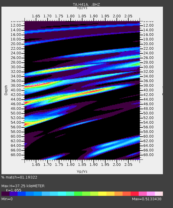
| Estimated Moho Depth: |
37.25 km |
| Estimated Crust Vp/Vs: |
1.65 |
| Assumed Crust Vp: |
6.41 km/s |
| Estimated Crust Vs: |
3.873 km/s |
| Estimated Crust Poisson's Ratio: |
0.21 |
|
| Radial Match: |
81.19322 % |
| Radial Bump: |
386 |
| Transverse Match: |
46.698097 % |
| Transverse Bump: |
400 |
| SOD ConfigId: |
508211 |
| Insert Time: |
2013-07-12 09:26:16.882 +0000 |
| GWidth: |
2.5 |
| Max Bumps: |
400 |
| Tol: |
0.001 |
|

Signal To Noise
| Channel | StoN | STA | LTA |
| TA:H41A: :BHZ:20130512T07:35:46.749998Z | 4.1668935 | 4.7860607E-7 | 1.148592E-7 |
| TA:H41A: :BHN:20130512T07:35:46.749998Z | 3.849405 | 2.9234403E-7 | 7.594525E-8 |
| TA:H41A: :BHE:20130512T07:35:46.749998Z | 0.73299444 | 6.8730465E-8 | 9.3766694E-8 |
| Arrivals |
| Ps | 4.1 SECOND |
| PpPs | 14 SECOND |
| PsPs/PpSs | 18 SECOND |


