You are here: Home > Network List > TA - USArray Transportable Network (new EarthScope stations) Stations List
> Station E42A Champion, MI, USA > Earthquake Result Viewer
E42A Champion, MI, USA - Earthquake Result Viewer
| Earthquake location: |
Near Coast Of Guatemala |
| Earthquake latitude/longitude: |
13.5/-91.4 |
| Earthquake time(UTC): |
2013/05/12 (132) 07:29:59 GMT |
| Earthquake Depth: |
11 km |
| Earthquake Magnitude: |
5.5 MS, 5.2 MB, 5.8 MW, 5.6 MW |
| Earthquake Catalog/Contributor: |
WHDF/NEIC |
|
| Network: |
TA USArray Transportable Network (new EarthScope stations) |
| Station: |
E42A Champion, MI, USA |
| Lat/Lon: |
46.43 N/87.91 W |
| Elevation: |
475 m |
|
| Distance: |
33.0 deg |
| Az: |
4.401 deg |
| Baz: |
186.196 deg |
| Ray Param: |
0.07841768 |
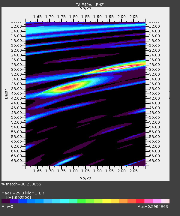
| Estimated Moho Depth: |
29.0 km |
| Estimated Crust Vp/Vs: |
1.99 |
| Assumed Crust Vp: |
6.472 km/s |
| Estimated Crust Vs: |
3.248 km/s |
| Estimated Crust Poisson's Ratio: |
0.33 |
|
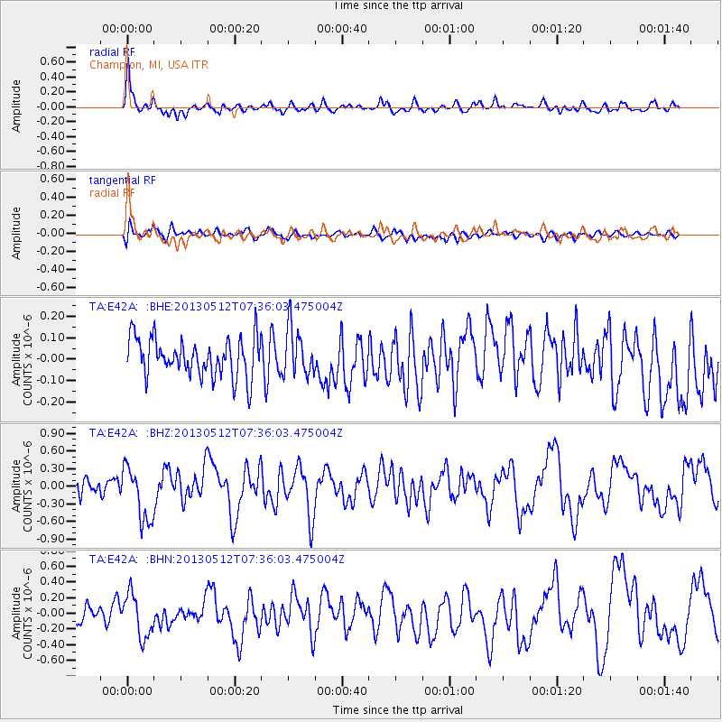
| Radial Match: |
80.233055 % |
| Radial Bump: |
371 |
| Transverse Match: |
45.530792 % |
| Transverse Bump: |
400 |
| SOD ConfigId: |
508211 |
| Insert Time: |
2013-07-12 09:27:29.019 +0000 |
| GWidth: |
2.5 |
| Max Bumps: |
400 |
| Tol: |
0.001 |
|
Signal To Noise
| Channel | StoN | STA | LTA |
| TA:E42A: :BHZ:20130512T07:36:03.475004Z | 3.0977292 | 4.672093E-7 | 1.5082315E-7 |
| TA:E42A: :BHN:20130512T07:36:03.475004Z | 2.949586 | 2.7787866E-7 | 9.4209376E-8 |
| TA:E42A: :BHE:20130512T07:36:03.475004Z | 1.2680988 | 1.124767E-7 | 8.86971E-8 |
| Arrivals |
| Ps | 4.8 SECOND |
| PpPs | 12 SECOND |
| PsPs/PpSs | 17 SECOND |


