You are here: Home > Network List > TA - USArray Transportable Network (new EarthScope stations) Stations List
> Station H47A Mio, MI, USA > Earthquake Result Viewer
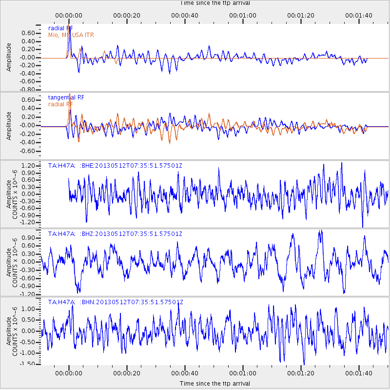
H47A Mio, MI, USA - Earthquake Result Viewer
*The percent match for this event was below the threshold and hence no stack was calculated.
| Earthquake location: |
Near Coast Of Guatemala |
| Earthquake latitude/longitude: |
13.5/-91.4 |
| Earthquake time(UTC): |
2013/05/12 (132) 07:29:59 GMT |
| Earthquake Depth: |
11 km |
| Earthquake Magnitude: |
5.5 MS, 5.2 MB, 5.8 MW, 5.6 MW |
| Earthquake Catalog/Contributor: |
WHDF/NEIC |
|
| Network: |
TA USArray Transportable Network (new EarthScope stations) |
| Station: |
H47A Mio, MI, USA |
| Lat/Lon: |
44.60 N/84.21 W |
| Elevation: |
356 m |
|
| Distance: |
31.6 deg |
| Az: |
9.793 deg |
| Baz: |
193.392 deg |
| Ray Param: |
$rayparam |
*The percent match for this event was below the threshold and hence was not used in the summary stack. |
|
| Radial Match: |
68.209305 % |
| Radial Bump: |
400 |
| Transverse Match: |
43.76265 % |
| Transverse Bump: |
400 |
| SOD ConfigId: |
508211 |
| Insert Time: |
2013-07-12 09:30:46.990 +0000 |
| GWidth: |
2.5 |
| Max Bumps: |
400 |
| Tol: |
0.001 |
|
Signal To Noise
| Channel | StoN | STA | LTA |
| TA:H47A: :BHZ:20130512T07:35:51.57501Z | 3.2117321 | 5.964831E-7 | 1.8572007E-7 |
| TA:H47A: :BHN:20130512T07:35:51.57501Z | 1.5538555 | 5.215722E-7 | 3.3566326E-7 |
| TA:H47A: :BHE:20130512T07:35:51.57501Z | 0.8130607 | 3.2736568E-7 | 4.0263376E-7 |
| Arrivals |
| Ps | |
| PpPs | |
| PsPs/PpSs | |


