You are here: Home > Network List > TA - USArray Transportable Network (new EarthScope stations) Stations List
> Station G47A Hillman, MI, USA > Earthquake Result Viewer
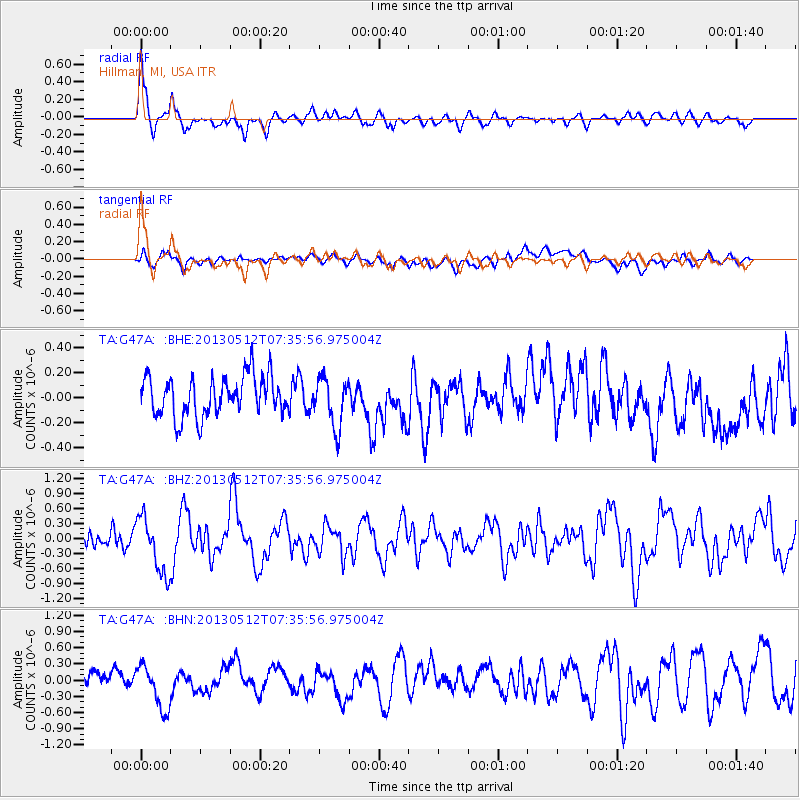
G47A Hillman, MI, USA - Earthquake Result Viewer
*The percent match for this event was below the threshold and hence no stack was calculated.
| Earthquake location: |
Near Coast Of Guatemala |
| Earthquake latitude/longitude: |
13.5/-91.4 |
| Earthquake time(UTC): |
2013/05/12 (132) 07:29:59 GMT |
| Earthquake Depth: |
11 km |
| Earthquake Magnitude: |
5.5 MS, 5.2 MB, 5.8 MW, 5.6 MW |
| Earthquake Catalog/Contributor: |
WHDF/NEIC |
|
| Network: |
TA USArray Transportable Network (new EarthScope stations) |
| Station: |
G47A Hillman, MI, USA |
| Lat/Lon: |
45.17 N/83.86 W |
| Elevation: |
239 m |
|
| Distance: |
32.2 deg |
| Az: |
9.996 deg |
| Baz: |
193.812 deg |
| Ray Param: |
$rayparam |
*The percent match for this event was below the threshold and hence was not used in the summary stack. |
|
| Radial Match: |
78.8828 % |
| Radial Bump: |
392 |
| Transverse Match: |
54.40359 % |
| Transverse Bump: |
400 |
| SOD ConfigId: |
508211 |
| Insert Time: |
2013-07-12 09:31:07.556 +0000 |
| GWidth: |
2.5 |
| Max Bumps: |
400 |
| Tol: |
0.001 |
|
Signal To Noise
| Channel | StoN | STA | LTA |
| TA:G47A: :BHZ:20130512T07:35:56.975004Z | 3.1518195 | 5.6495907E-7 | 1.7924854E-7 |
| TA:G47A: :BHN:20130512T07:35:56.975004Z | 2.6396961 | 3.9739484E-7 | 1.5054569E-7 |
| TA:G47A: :BHE:20130512T07:35:56.975004Z | 1.2238202 | 1.9396764E-7 | 1.5849358E-7 |
| Arrivals |
| Ps | |
| PpPs | |
| PsPs/PpSs | |


