You are here: Home > Network List > TA - USArray Transportable Network (new EarthScope stations) Stations List
> Station O60A Telford, PA, USA > Earthquake Result Viewer
O60A Telford, PA, USA - Earthquake Result Viewer
| Earthquake location: |
Near Coast Of Guatemala |
| Earthquake latitude/longitude: |
13.5/-91.4 |
| Earthquake time(UTC): |
2013/05/12 (132) 07:29:59 GMT |
| Earthquake Depth: |
11 km |
| Earthquake Magnitude: |
5.5 MS, 5.2 MB, 5.8 MW, 5.6 MW |
| Earthquake Catalog/Contributor: |
WHDF/NEIC |
|
| Network: |
TA USArray Transportable Network (new EarthScope stations) |
| Station: |
O60A Telford, PA, USA |
| Lat/Lon: |
40.32 N/75.40 W |
| Elevation: |
70 m |
|
| Distance: |
30.2 deg |
| Az: |
24.731 deg |
| Baz: |
212.159 deg |
| Ray Param: |
0.07939577 |
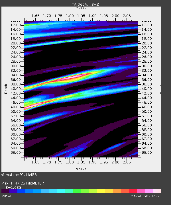
| Estimated Moho Depth: |
47.25 km |
| Estimated Crust Vp/Vs: |
1.63 |
| Assumed Crust Vp: |
6.283 km/s |
| Estimated Crust Vs: |
3.843 km/s |
| Estimated Crust Poisson's Ratio: |
0.20 |
|
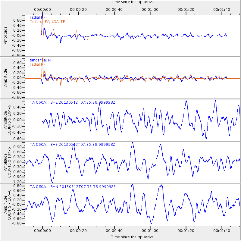
| Radial Match: |
91.16455 % |
| Radial Bump: |
327 |
| Transverse Match: |
68.19461 % |
| Transverse Bump: |
400 |
| SOD ConfigId: |
508211 |
| Insert Time: |
2013-07-12 09:32:32.170 +0000 |
| GWidth: |
2.5 |
| Max Bumps: |
400 |
| Tol: |
0.001 |
|
Signal To Noise
| Channel | StoN | STA | LTA |
| TA:O60A: :BHZ:20130512T07:35:38.999998Z | 1.9632083 | 4.1664828E-7 | 2.1222826E-7 |
| TA:O60A: :BHN:20130512T07:35:38.999998Z | 2.5985775 | 2.5712546E-7 | 9.894855E-8 |
| TA:O60A: :BHE:20130512T07:35:38.999998Z | 2.1690238 | 2.4371263E-7 | 1.1236051E-7 |
| Arrivals |
| Ps | 5.2 SECOND |
| PpPs | 18 SECOND |
| PsPs/PpSs | 23 SECOND |


