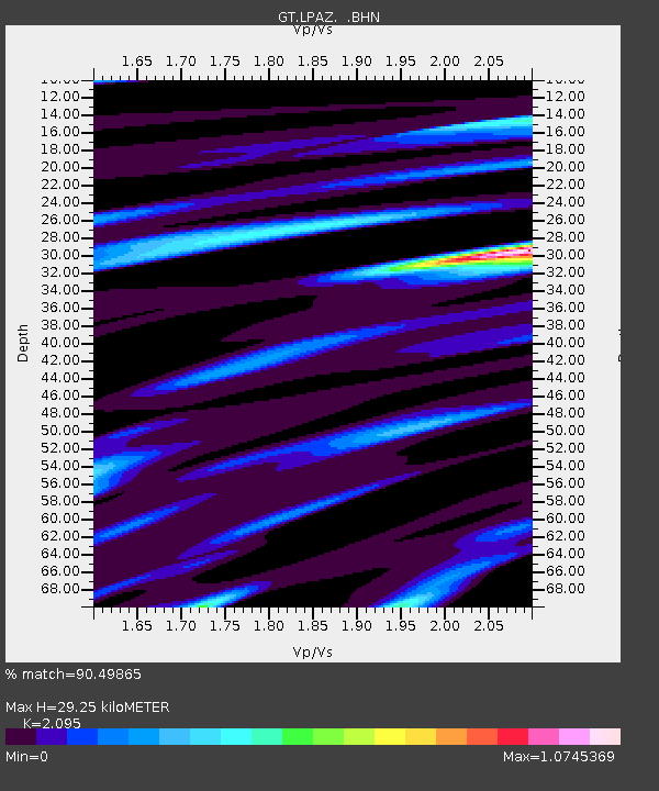
LPAZ La Paz , Bolivia - Earthquake Result Viewer

Earthquake location: Near Coast Of Oaxaca, Mexico
Earthquake latitude/longitude: 15.5/-94.7
Earthquake time(UTC): 1993/09/30 (273) 18:27:53 GMT
Earthquake Depth: 33 km
Earthquake Magnitude: 5.6 MB, 6.4 MS, 6.5 UNKNOWN, 6.7 MW
Earthquake Catalog/Contributor: WHDF/NEIC
Network: GT Global Telemetered Seismograph Network (USAF/USGS)
Station: LPAZ La Paz , Bolivia
Lat/Lon: 16.29 S/68.13 W
Elevation: 4769 m
Distance: 41.1 deg
Az: 139.151 deg
Baz: 318.961 deg
Ray Param: 0.073957354
Estimated Moho Depth: 29.25 km
Estimated Crust Vp/Vs: 2.10
Assumed Crust Vp: 6.454 km/s
Estimated Crust Vs: 3.081 km/s
Estimated Crust Poisson's Ratio: 0.35
Radial Match: 90.49865 %
Radial Bump: 348
Transverse Match: 72.6004 %
Transverse Bump: 400
SOD ConfigId: 16938
Insert Time: 2010-02-27 02:09:32.167 +0000
GWidth: 2.5
Max Bumps: 400
Tol: 0.001

Signal To Noise

ChannelStoNSTALTA
GT:LPAZ: :BHN:19930930T18:35:02.840009Z4.7111483.8273234E-78.123972E-8
GT:LPAZ: :BHE:19930930T18:35:02.840009Z3.75745183.4241378E-79.112925E-8
GT:LPAZ: :BHZ:19930930T18:35:02.840009Z5.2304476.5756876E-71.2571941E-7
Arrivals
Ps5.3 SECOND
PpPs13 SECOND
PsPs/PpSs18 SECOND