You are here: Home > Network List > GT - Global Telemetered Seismograph Network (USAF/USGS) Stations List
> Station LPAZ La Paz , Bolivia > Earthquake Result Viewer
LPAZ La Paz , Bolivia - Earthquake Result Viewer
| Earthquake location: |
Southern California |
| Earthquake latitude/longitude: |
34.2/-118.5 |
| Earthquake time(UTC): |
1994/01/17 (017) 12:30:55 GMT |
| Earthquake Depth: |
18 km |
| Earthquake Magnitude: |
6.4 MB, 6.8 MS, 6.7 UNKNOWN, 6.7 MW |
| Earthquake Catalog/Contributor: |
WHDF/NEIC |
|
| Network: |
GT Global Telemetered Seismograph Network (USAF/USGS) |
| Station: |
LPAZ La Paz , Bolivia |
| Lat/Lon: |
16.29 S/68.13 W |
| Elevation: |
4769 m |
|
| Distance: |
69.4 deg |
| Az: |
127.778 deg |
| Baz: |
316.997 deg |
| Ray Param: |
0.055631954 |
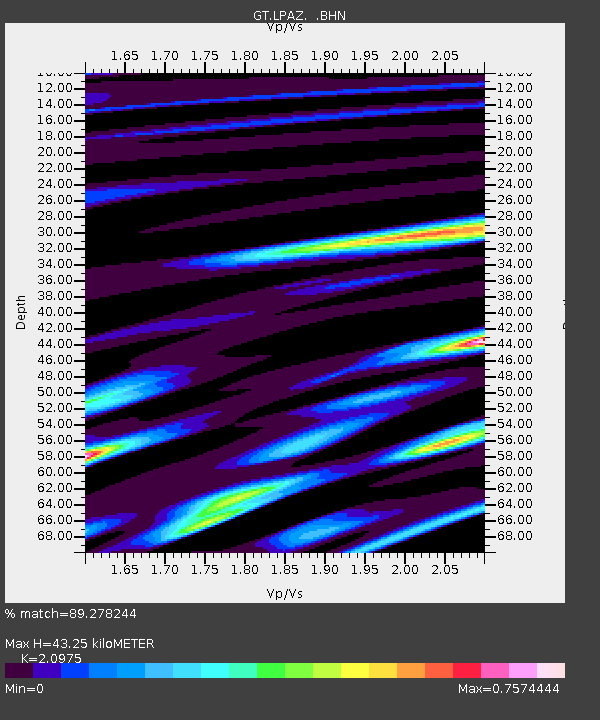
| Estimated Moho Depth: |
43.25 km |
| Estimated Crust Vp/Vs: |
2.10 |
| Assumed Crust Vp: |
6.454 km/s |
| Estimated Crust Vs: |
3.077 km/s |
| Estimated Crust Poisson's Ratio: |
0.35 |
|
| Radial Match: |
89.278244 % |
| Radial Bump: |
400 |
| Transverse Match: |
82.76012 % |
| Transverse Bump: |
400 |
| SOD ConfigId: |
16938 |
| Insert Time: |
2010-02-27 02:09:38.020 +0000 |
| GWidth: |
2.5 |
| Max Bumps: |
400 |
| Tol: |
0.001 |
|

Signal To Noise
| Channel | StoN | STA | LTA |
| GT:LPAZ: :BHN:19940117T12:41:30.742017Z | 7.9342456 | 5.2687255E-7 | 6.640487E-8 |
| GT:LPAZ: :BHE:19940117T12:41:30.742017Z | 9.530888 | 4.0713172E-7 | 4.2717083E-8 |
| GT:LPAZ: :BHZ:19940117T12:41:30.742017Z | 20.089941 | 1.295778E-6 | 6.449885E-8 |
| Arrivals |
| Ps | 7.6 SECOND |
| PpPs | 20 SECOND |
| PsPs/PpSs | 28 SECOND |


