You are here: Home > Network List > TA - USArray Transportable Network (new EarthScope stations) Stations List
> Station U41A Viola, AR, USA > Earthquake Result Viewer
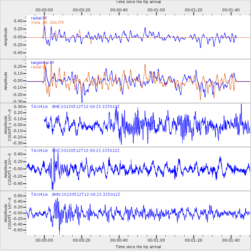
U41A Viola, AR, USA - Earthquake Result Viewer
*The percent match for this event was below the threshold and hence no stack was calculated.
| Earthquake location: |
Northern Chile |
| Earthquake latitude/longitude: |
-26.2/-69.4 |
| Earthquake time(UTC): |
2013/05/12 (132) 12:59:10 GMT |
| Earthquake Depth: |
10 km |
| Earthquake Magnitude: |
5.5 MB, 4.7 MS, 5.4 MW, 5.1 ML |
| Earthquake Catalog/Contributor: |
WHDF/NEIC |
|
| Network: |
TA USArray Transportable Network (new EarthScope stations) |
| Station: |
U41A Viola, AR, USA |
| Lat/Lon: |
36.34 N/91.92 W |
| Elevation: |
300 m |
|
| Distance: |
65.7 deg |
| Az: |
340.2 deg |
| Baz: |
157.847 deg |
| Ray Param: |
$rayparam |
*The percent match for this event was below the threshold and hence was not used in the summary stack. |
|
| Radial Match: |
41.55044 % |
| Radial Bump: |
400 |
| Transverse Match: |
47.484245 % |
| Transverse Bump: |
400 |
| SOD ConfigId: |
508211 |
| Insert Time: |
2013-07-12 09:41:51.377 +0000 |
| GWidth: |
2.5 |
| Max Bumps: |
400 |
| Tol: |
0.001 |
|
Signal To Noise
| Channel | StoN | STA | LTA |
| TA:U41A: :BHZ:20130512T13:09:23.325012Z | 2.7675815 | 2.0382558E-7 | 7.364754E-8 |
| TA:U41A: :BHN:20130512T13:09:23.325012Z | 1.2859879 | 1.626011E-7 | 1.2644063E-7 |
| TA:U41A: :BHE:20130512T13:09:23.325012Z | 1.0219913 | 7.7019166E-8 | 7.536186E-8 |
| Arrivals |
| Ps | |
| PpPs | |
| PsPs/PpSs | |


