You are here: Home > Network List > TA - USArray Transportable Network (new EarthScope stations) Stations List
> Station N44A Piper City, IL, USA > Earthquake Result Viewer
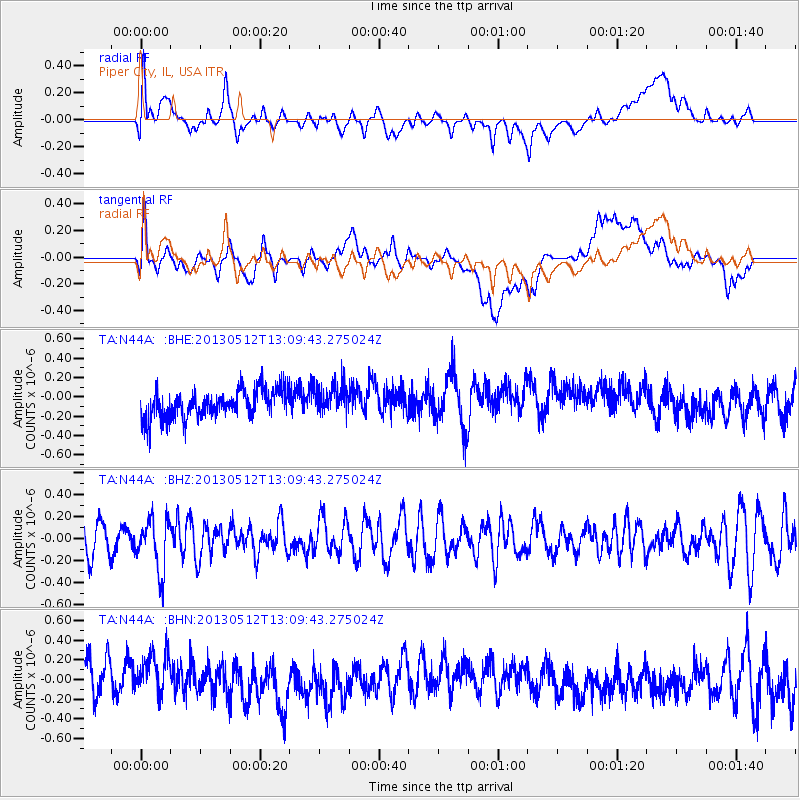
N44A Piper City, IL, USA - Earthquake Result Viewer
*The percent match for this event was below the threshold and hence no stack was calculated.
| Earthquake location: |
Northern Chile |
| Earthquake latitude/longitude: |
-26.2/-69.4 |
| Earthquake time(UTC): |
2013/05/12 (132) 12:59:10 GMT |
| Earthquake Depth: |
10 km |
| Earthquake Magnitude: |
5.5 MB, 4.7 MS, 5.4 MW, 5.1 ML |
| Earthquake Catalog/Contributor: |
WHDF/NEIC |
|
| Network: |
TA USArray Transportable Network (new EarthScope stations) |
| Station: |
N44A Piper City, IL, USA |
| Lat/Lon: |
40.80 N/88.13 W |
| Elevation: |
202 m |
|
| Distance: |
68.8 deg |
| Az: |
344.877 deg |
| Baz: |
162.01 deg |
| Ray Param: |
$rayparam |
*The percent match for this event was below the threshold and hence was not used in the summary stack. |
|
| Radial Match: |
53.31045 % |
| Radial Bump: |
400 |
| Transverse Match: |
50.074463 % |
| Transverse Bump: |
400 |
| SOD ConfigId: |
508211 |
| Insert Time: |
2013-07-12 09:42:51.825 +0000 |
| GWidth: |
2.5 |
| Max Bumps: |
400 |
| Tol: |
0.001 |
|
Signal To Noise
| Channel | StoN | STA | LTA |
| TA:N44A: :BHZ:20130512T13:09:43.275024Z | 1.8374177 | 2.3905932E-7 | 1.3010614E-7 |
| TA:N44A: :BHN:20130512T13:09:43.275024Z | 1.526192 | 2.3049031E-7 | 1.5102316E-7 |
| TA:N44A: :BHE:20130512T13:09:43.275024Z | 1.0535595 | 1.529224E-7 | 1.4514832E-7 |
| Arrivals |
| Ps | |
| PpPs | |
| PsPs/PpSs | |


