LPAZ La Paz , Bolivia - Earthquake Result Viewer
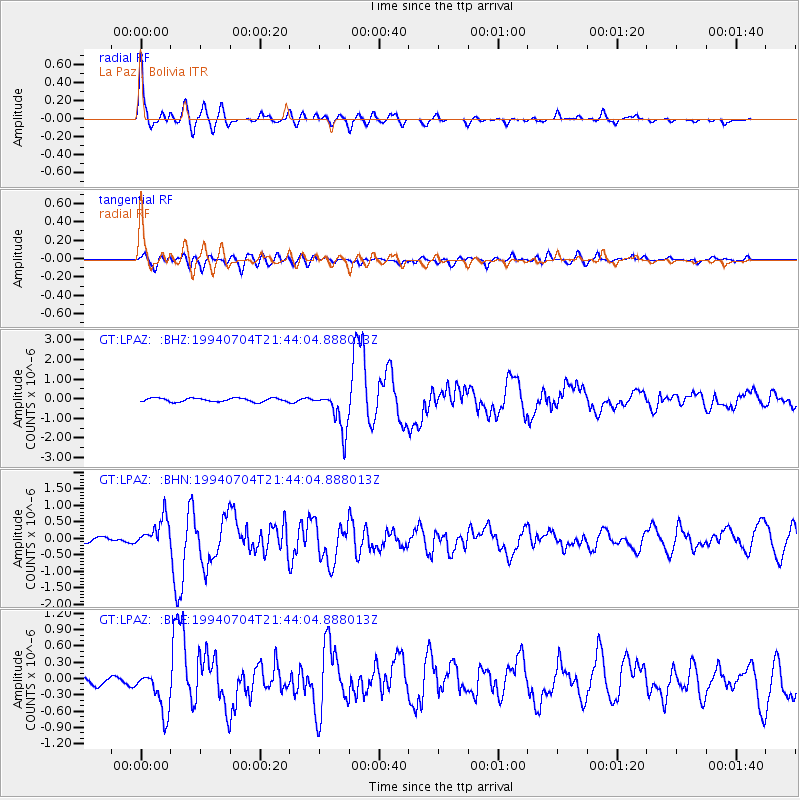
Earthquake location: Off Coast Of Oaxaca, Mexico
Earthquake latitude/longitude: 14.9/-97.3
Earthquake time(UTC): 1994/07/04 (185) 21:36:44 GMT
Earthquake Depth: 33 km
Earthquake Magnitude: 6.1 MB, 6.1 MS, 6.5 UNKNOWN, 6.5 MD
Earthquake Catalog/Contributor: WHDF/NEIC
Network: GT Global Telemetered Seismograph Network (USAF/USGS)
Station: LPAZ La Paz , Bolivia
Lat/Lon: 16.29 S/68.13 W
Elevation: 4769 m
Distance: 42.4 deg
Az: 135.948 deg
Baz: 315.585 deg
Ray Param: 0.073161714
Estimated Moho Depth: 64.25 km
Estimated Crust Vp/Vs: 1.69
Assumed Crust Vp: 6.454 km/s
Estimated Crust Vs: 3.825 km/s
Estimated Crust Poisson's Ratio: 0.23
Radial Match: 89.549324 %
Radial Bump: 400
Transverse Match: 66.5513 %
Transverse Bump: 400
SOD ConfigId: 16938
Insert Time: 2010-02-27 02:09:40.318 +0000
GWidth: 2.5
Max Bumps: 400
Tol: 0.001

Signal To Noise

ChannelStoNSTALTA
GT:LPAZ: :BHN:19940704T21:44:04.888013Z7.39687974.5197706E-76.110375E-8
GT:LPAZ: :BHE:19940704T21:44:04.888013Z4.2198794.0060644E-79.4933156E-8
GT:LPAZ: :BHZ:19940704T21:44:04.888013Z11.0796561.0511989E-69.487649E-8
Arrivals
Ps7.4 SECOND
PpPs25 SECOND
PsPs/PpSs32 SECOND