You are here: Home > Network List > GT - Global Telemetered Seismograph Network (USAF/USGS) Stations List
> Station LPAZ La Paz , Bolivia > Earthquake Result Viewer
LPAZ La Paz , Bolivia - Earthquake Result Viewer
| Earthquake location: |
Southwestern Atlantic Ocean |
| Earthquake latitude/longitude: |
-59.9/-18.5 |
| Earthquake time(UTC): |
1994/05/06 (126) 18:20:38 GMT |
| Earthquake Depth: |
10 km |
| Earthquake Magnitude: |
5.3 MB, 5.7 MS |
| Earthquake Catalog/Contributor: |
WHDF/NEIC |
|
| Network: |
GT Global Telemetered Seismograph Network (USAF/USGS) |
| Station: |
LPAZ La Paz , Bolivia |
| Lat/Lon: |
16.29 S/68.13 W |
| Elevation: |
4769 m |
|
| Distance: |
56.4 deg |
| Az: |
298.493 deg |
| Baz: |
152.571 deg |
| Ray Param: |
0.06419199 |
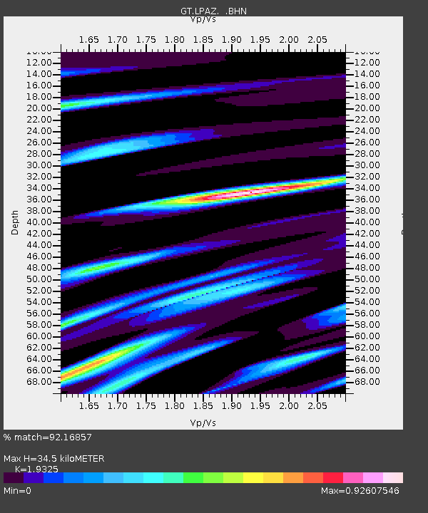
| Estimated Moho Depth: |
34.5 km |
| Estimated Crust Vp/Vs: |
1.93 |
| Assumed Crust Vp: |
6.454 km/s |
| Estimated Crust Vs: |
3.34 km/s |
| Estimated Crust Poisson's Ratio: |
0.32 |
|
| Radial Match: |
92.16857 % |
| Radial Bump: |
400 |
| Transverse Match: |
84.60473 % |
| Transverse Bump: |
400 |
| SOD ConfigId: |
17000 |
| Insert Time: |
2010-02-27 02:09:44.316 +0000 |
| GWidth: |
2.5 |
| Max Bumps: |
400 |
| Tol: |
0.001 |
|

Signal To Noise
| Channel | StoN | STA | LTA |
| GT:LPAZ: :BHN:19940506T18:29:48.790002Z | 2.2712154 | 2.0168045E-7 | 8.879847E-8 |
| GT:LPAZ: :BHE:19940506T18:29:48.790002Z | 3.1385155 | 2.9754446E-7 | 9.48042E-8 |
| GT:LPAZ: :BHZ:19940506T18:29:48.790002Z | 4.547989 | 6.162117E-7 | 1.3549104E-7 |
| Arrivals |
| Ps | 5.2 SECOND |
| PpPs | 15 SECOND |
| PsPs/PpSs | 20 SECOND |


