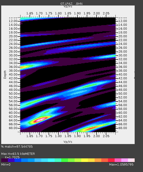
LPAZ La Paz , Bolivia - Earthquake Result Viewer
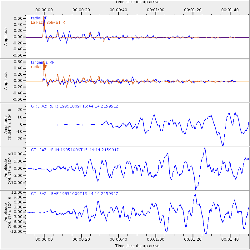
Earthquake location: Near Coast Of Jalisco, Mexico
Earthquake latitude/longitude: 19.1/-104.2
Earthquake time(UTC): 1995/10/09 (282) 15:35:55 GMT
Earthquake Depth: 49 km
Earthquake Magnitude: 6.5 MB, 7.3 MS, 7.3 UNKNOWN, 7.9 MW
Earthquake Catalog/Contributor: WHDF/NEIC
Network: GT Global Telemetered Seismograph Network (USAF/USGS)
Station: LPAZ La Paz , Bolivia
Lat/Lon: 16.29 S/68.13 W
Elevation: 4769 m
Distance: 50.0 deg
Az: 132.398 deg
Baz: 313.37 deg
Ray Param: 0.06822213
Estimated Moho Depth: 63.5 km
Estimated Crust Vp/Vs: 1.70
Assumed Crust Vp: 6.454 km/s
Estimated Crust Vs: 3.791 km/s
Estimated Crust Poisson's Ratio: 0.24
Radial Match: 97.544785 %
Radial Bump: 341
Transverse Match: 88.31601 %
Transverse Bump: 400
SOD ConfigId: 6273
Insert Time: 2010-02-27 02:09:45.342 +0000
GWidth: 2.5
Max Bumps: 400
Tol: 0.001

Signal To Noise

ChannelStoNSTALTA
GT:LPAZ: :BHN:19951009T15:44:14.215991Z6.2923589.95618E-71.5822654E-7
GT:LPAZ: :BHE:19951009T15:44:14.215991Z5.04061758.63853E-71.7137842E-7
GT:LPAZ: :BHZ:19951009T15:44:14.215991Z10.1996712.3961632E-62.3492555E-7
Arrivals
Ps7.3 SECOND
PpPs25 SECOND
PsPs/PpSs32 SECOND