You are here: Home > Network List > GT - Global Telemetered Seismograph Network (USAF/USGS) Stations List
> Station LPAZ La Paz , Bolivia > Earthquake Result Viewer
LPAZ La Paz , Bolivia - Earthquake Result Viewer

| Earthquake location: |
Baja California, Mexico |
| Earthquake latitude/longitude: |
24.6/-110.3 |
| Earthquake time(UTC): |
1995/06/30 (181) 11:58:56 GMT |
| Earthquake Depth: |
10 km |
| Earthquake Magnitude: |
5.8 MB, 6.3 MS, 6.2 UNKNOWN |
| Earthquake Catalog/Contributor: |
WHDF/NEIC |
|
| Network: |
GT Global Telemetered Seismograph Network (USAF/USGS) |
| Station: |
LPAZ La Paz , Bolivia |
| Lat/Lon: |
16.29 S/68.13 W |
| Elevation: |
4769 m |
|
| Distance: |
57.8 deg |
| Az: |
130.422 deg |
| Baz: |
313.824 deg |
| Ray Param: |
0.06325323 |
| Estimated Moho Depth: |
23.5 km |
| Estimated Crust Vp/Vs: |
2.09 |
| Assumed Crust Vp: |
6.454 km/s |
| Estimated Crust Vs: |
3.092 km/s |
| Estimated Crust Poisson's Ratio: |
0.35 |
|
| Radial Match: |
86.93552 % |
| Radial Bump: |
400 |
| Transverse Match: |
78.68764 % |
| Transverse Bump: |
400 |
| SOD ConfigId: |
6273 |
| Insert Time: |
2010-02-27 02:09:46.893 +0000 |
| GWidth: |
2.5 |
| Max Bumps: |
400 |
| Tol: |
0.001 |
|
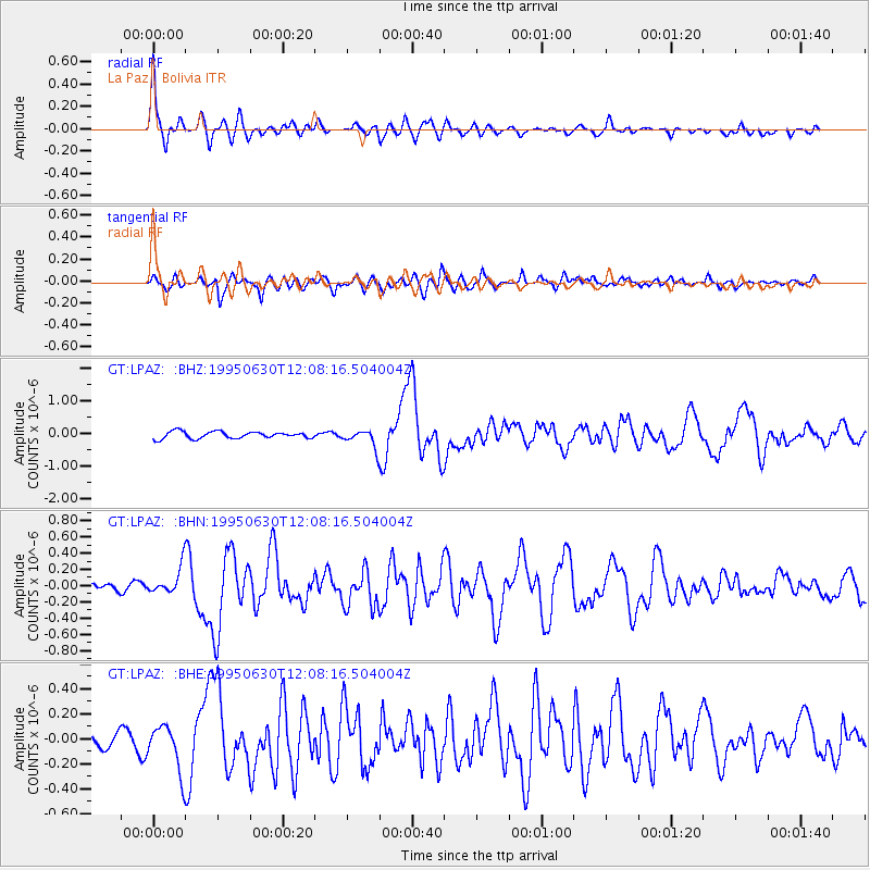
Signal To Noise
| Channel | StoN | STA | LTA |
| GT:LPAZ: :BHN:19950630T12:08:16.504004Z | 3.2174752 | 1.7229856E-7 | 5.3550856E-8 |
| GT:LPAZ: :BHE:19950630T12:08:16.504004Z | 2.862661 | 1.902904E-7 | 6.647326E-8 |
| GT:LPAZ: :BHZ:19950630T12:08:16.504004Z | 3.4813805 | 3.5822822E-7 | 1.02898326E-7 |
| Arrivals |
| Ps | 4.1 SECOND |
| PpPs | 11 SECOND |
| PsPs/PpSs | 15 SECOND |


