You are here: Home > Network List > CI - Caltech Regional Seismic Network Stations List
> Station SLA SLA, Trona, CA, USA > Earthquake Result Viewer
SLA SLA, Trona, CA, USA - Earthquake Result Viewer
| Earthquake location: |
Near East Coast Of Kamchatka |
| Earthquake latitude/longitude: |
56.3/163.8 |
| Earthquake time(UTC): |
2001/08/02 (214) 23:41:06 GMT |
| Earthquake Depth: |
14 km |
| Earthquake Magnitude: |
5.9 MB, 6.2 MS, 6.3 MW, 6.2 ME |
| Earthquake Catalog/Contributor: |
WHDF/NEIC |
|
| Network: |
CI Caltech Regional Seismic Network |
| Station: |
SLA SLA, Trona, CA, USA |
| Lat/Lon: |
35.89 N/117.28 W |
| Elevation: |
1174 m |
|
| Distance: |
55.2 deg |
| Az: |
76.164 deg |
| Baz: |
318.144 deg |
| Ray Param: |
0.06497104 |
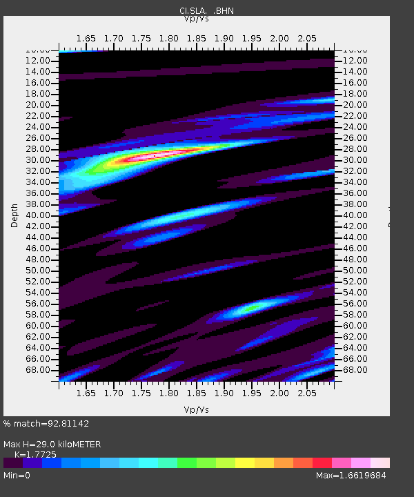
| Estimated Moho Depth: |
29.0 km |
| Estimated Crust Vp/Vs: |
1.77 |
| Assumed Crust Vp: |
6.276 km/s |
| Estimated Crust Vs: |
3.541 km/s |
| Estimated Crust Poisson's Ratio: |
0.27 |
|
| Radial Match: |
92.81142 % |
| Radial Bump: |
400 |
| Transverse Match: |
86.41796 % |
| Transverse Bump: |
400 |
| SOD ConfigId: |
3770 |
| Insert Time: |
2010-02-25 20:28:44.086 +0000 |
| GWidth: |
2.5 |
| Max Bumps: |
400 |
| Tol: |
0.001 |
|
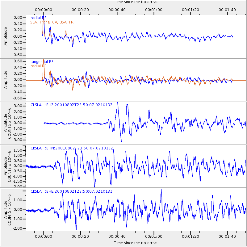
Signal To Noise
| Channel | StoN | STA | LTA |
| CI:SLA: :BHN:20010802T23:50:07.021013Z | 0.5064865 | 5.308593E-8 | 1.0481214E-7 |
| CI:SLA: :BHE:20010802T23:50:07.021013Z | 1.0647846 | 1.1538851E-7 | 1.0836793E-7 |
| CI:SLA: :BHZ:20010802T23:50:07.021013Z | 1.0632162 | 8.4660755E-8 | 7.9627036E-8 |
| Arrivals |
| Ps | 3.8 SECOND |
| PpPs | 12 SECOND |
| PsPs/PpSs | 16 SECOND |


