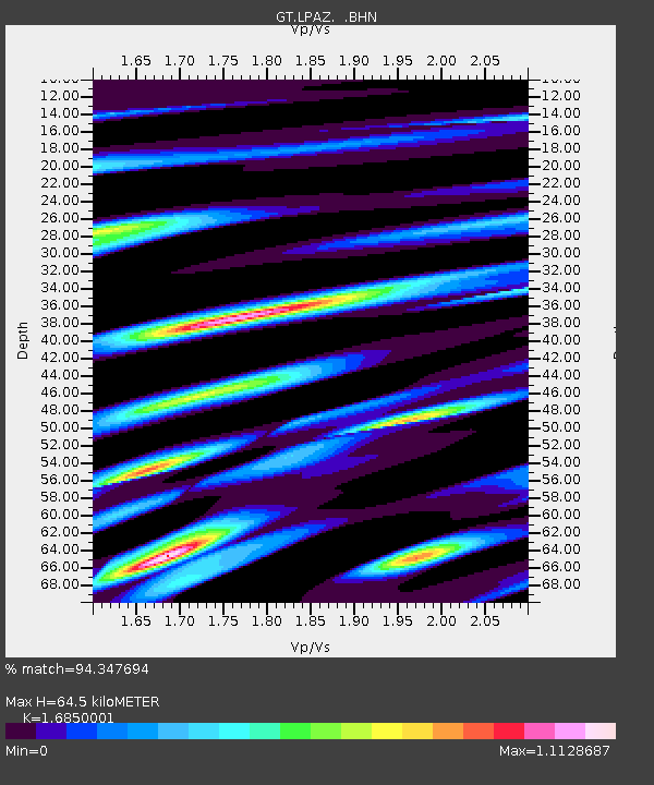
LPAZ La Paz , Bolivia - Earthquake Result Viewer
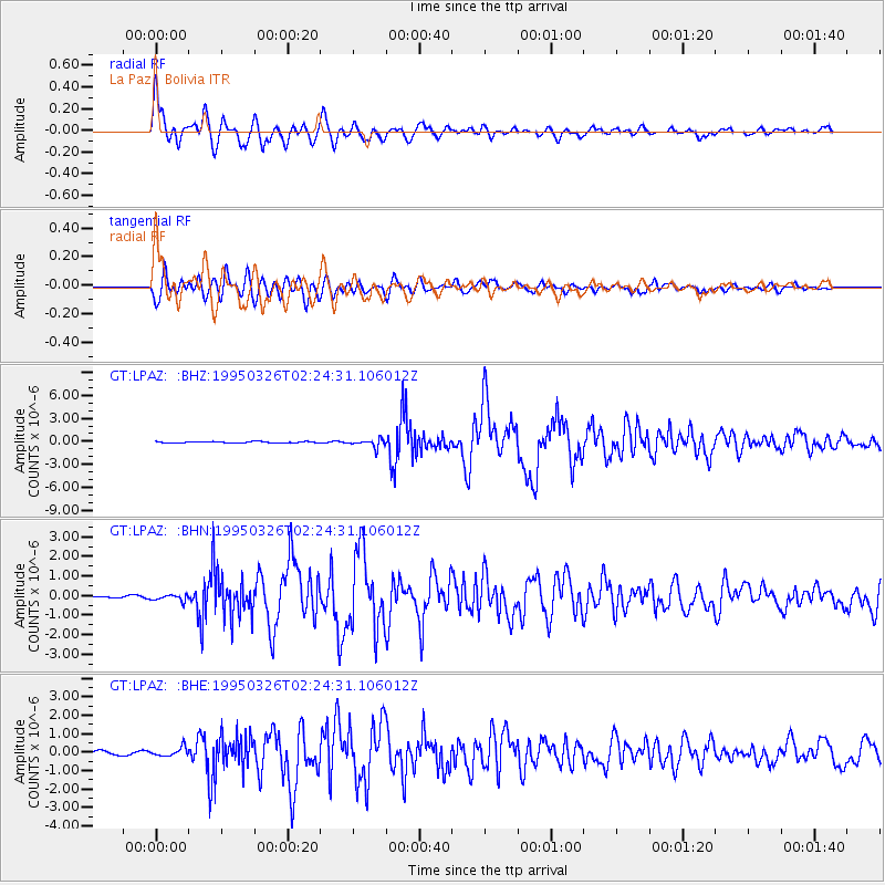
Earthquake location: South Sandwich Islands Region
Earthquake latitude/longitude: -55.9/-28.2
Earthquake time(UTC): 1995/03/26 (085) 02:16:16 GMT
Earthquake Depth: 77 km
Earthquake Magnitude: 6.1 MB, 5.9 MS, 6.4 UNKNOWN, 6.3 MW
Earthquake Catalog/Contributor: WHDF/NEIC
Network: GT Global Telemetered Seismograph Network (USAF/USGS)
Station: LPAZ La Paz , Bolivia
Lat/Lon: 16.29 S/68.13 W
Elevation: 4769 m
Distance: 49.8 deg
Az: 306.201 deg
Baz: 151.719 deg
Ray Param: 0.06824339
Estimated Moho Depth: 64.5 km
Estimated Crust Vp/Vs: 1.69
Assumed Crust Vp: 6.454 km/s
Estimated Crust Vs: 3.83 km/s
Estimated Crust Poisson's Ratio: 0.23
Radial Match: 94.347694 %
Radial Bump: 400
Transverse Match: 84.191925 %
Transverse Bump: 400
SOD ConfigId: 6273
Insert Time: 2010-02-27 02:09:52.021 +0000
GWidth: 2.5
Max Bumps: 400
Tol: 0.001

Signal To Noise

ChannelStoNSTALTA
GT:LPAZ: :BHN:19950326T02:24:31.106012Z2.2860761.567849E-76.8582544E-8
GT:LPAZ: :BHE:19950326T02:24:31.106012Z2.15573292.401686E-71.1140926E-7
GT:LPAZ: :BHZ:19950326T02:24:31.106012Z5.90723375.000396E-78.464869E-8
Arrivals
Ps7.3 SECOND
PpPs25 SECOND
PsPs/PpSs33 SECOND