You are here: Home > Network List > GT - Global Telemetered Seismograph Network (USAF/USGS) Stations List
> Station LPAZ La Paz , Bolivia > Earthquake Result Viewer
LPAZ La Paz , Bolivia - Earthquake Result Viewer
| Earthquake location: |
Gulf Of California |
| Earthquake latitude/longitude: |
26.2/-110.3 |
| Earthquake time(UTC): |
1995/08/28 (240) 10:46:12 GMT |
| Earthquake Depth: |
10 km |
| Earthquake Magnitude: |
5.6 MB, 6.5 MS |
| Earthquake Catalog/Contributor: |
WHDF/NEIC |
|
| Network: |
GT Global Telemetered Seismograph Network (USAF/USGS) |
| Station: |
LPAZ La Paz , Bolivia |
| Lat/Lon: |
16.29 S/68.13 W |
| Elevation: |
4769 m |
|
| Distance: |
58.9 deg |
| Az: |
131.07 deg |
| Baz: |
315.128 deg |
| Ray Param: |
0.06256407 |
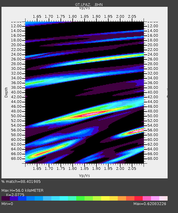
| Estimated Moho Depth: |
56.0 km |
| Estimated Crust Vp/Vs: |
2.08 |
| Assumed Crust Vp: |
6.454 km/s |
| Estimated Crust Vs: |
3.107 km/s |
| Estimated Crust Poisson's Ratio: |
0.35 |
|
| Radial Match: |
88.401985 % |
| Radial Bump: |
400 |
| Transverse Match: |
77.68126 % |
| Transverse Bump: |
400 |
| SOD ConfigId: |
6273 |
| Insert Time: |
2010-02-27 02:09:56.093 +0000 |
| GWidth: |
2.5 |
| Max Bumps: |
400 |
| Tol: |
0.001 |
|
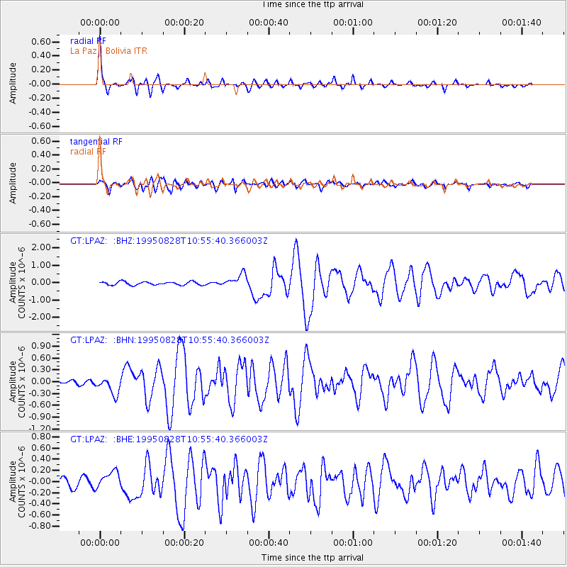
Signal To Noise
| Channel | StoN | STA | LTA |
| GT:LPAZ: :BHN:19950828T10:55:40.366003Z | 3.8353124 | 2.1776111E-7 | 5.6777935E-8 |
| GT:LPAZ: :BHE:19950828T10:55:40.366003Z | 2.2955704 | 1.590313E-7 | 6.927747E-8 |
| GT:LPAZ: :BHZ:19950828T10:55:40.366003Z | 4.108955 | 3.9364215E-7 | 9.5801035E-8 |
| Arrivals |
| Ps | 9.7 SECOND |
| PpPs | 26 SECOND |
| PsPs/PpSs | 35 SECOND |


