You are here: Home > Network List > GT - Global Telemetered Seismograph Network (USAF/USGS) Stations List
> Station LPAZ La Paz , Bolivia > Earthquake Result Viewer
LPAZ La Paz , Bolivia - Earthquake Result Viewer
| Earthquake location: |
Southern Pacific Ocean |
| Earthquake latitude/longitude: |
-36.0/-102.5 |
| Earthquake time(UTC): |
1997/05/29 (149) 17:02:38 GMT |
| Earthquake Depth: |
10 km |
| Earthquake Magnitude: |
5.6 MB, 6.1 MS, 6.5 UNKNOWN, 6.4 MW |
| Earthquake Catalog/Contributor: |
WHDF/NEIC |
|
| Network: |
GT Global Telemetered Seismograph Network (USAF/USGS) |
| Station: |
LPAZ La Paz , Bolivia |
| Lat/Lon: |
16.29 S/68.13 W |
| Elevation: |
4769 m |
|
| Distance: |
36.3 deg |
| Az: |
66.367 deg |
| Baz: |
230.704 deg |
| Ray Param: |
0.07675818 |
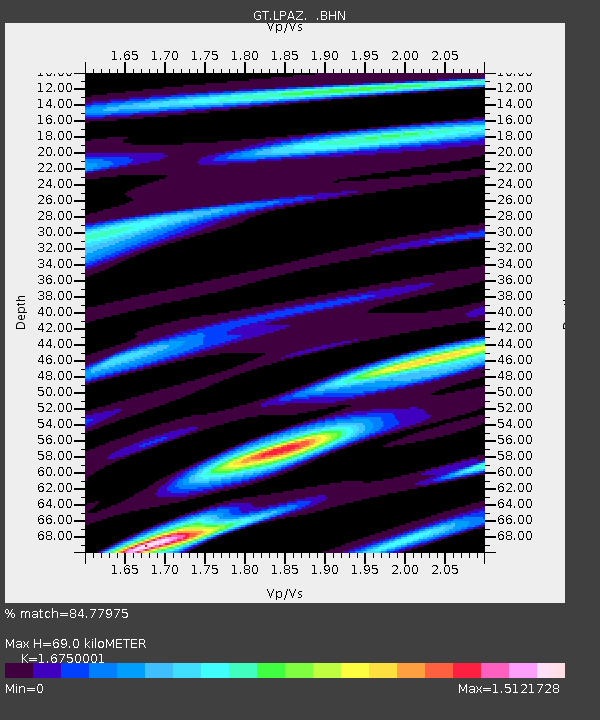
| Estimated Moho Depth: |
69.0 km |
| Estimated Crust Vp/Vs: |
1.68 |
| Assumed Crust Vp: |
6.454 km/s |
| Estimated Crust Vs: |
3.853 km/s |
| Estimated Crust Poisson's Ratio: |
0.22 |
|
| Radial Match: |
84.77975 % |
| Radial Bump: |
400 |
| Transverse Match: |
78.991035 % |
| Transverse Bump: |
400 |
| SOD ConfigId: |
6273 |
| Insert Time: |
2010-02-27 02:10:04.778 +0000 |
| GWidth: |
2.5 |
| Max Bumps: |
400 |
| Tol: |
0.001 |
|

Signal To Noise
| Channel | StoN | STA | LTA |
| GT:LPAZ: :BHN:19970529T17:09:12.439014Z | 0.59664583 | 5.131665E-8 | 8.600856E-8 |
| GT:LPAZ: :BHE:19970529T17:09:12.439014Z | 0.482812 | 5.431774E-8 | 1.1250289E-7 |
| GT:LPAZ: :BHZ:19970529T17:09:12.439014Z | 2.3218617 | 1.9303117E-7 | 8.313638E-8 |
| Arrivals |
| Ps | 7.8 SECOND |
| PpPs | 26 SECOND |
| PsPs/PpSs | 34 SECOND |


