You are here: Home > Network List > KN - Kyrgyz Seismic Telemetry Network Stations List
> Station UCH - > Earthquake Result Viewer
UCH - - Earthquake Result Viewer
| Earthquake location: |
Off East Coast Of Honshu, Japan |
| Earthquake latitude/longitude: |
37.1/142.4 |
| Earthquake time(UTC): |
2014/07/11 (192) 19:22:00 GMT |
| Earthquake Depth: |
13 km |
| Earthquake Magnitude: |
6.8 MWP, 6.8 MI |
| Earthquake Catalog/Contributor: |
NEIC PDE/NEIC COMCAT |
|
| Network: |
KN Kyrgyz Seismic Telemetry Network |
| Station: |
UCH - |
| Lat/Lon: |
42.23 N/74.51 E |
| Elevation: |
3850 m |
|
| Distance: |
51.3 deg |
| Az: |
298.113 deg |
| Baz: |
71.78 deg |
| Ray Param: |
0.067521535 |
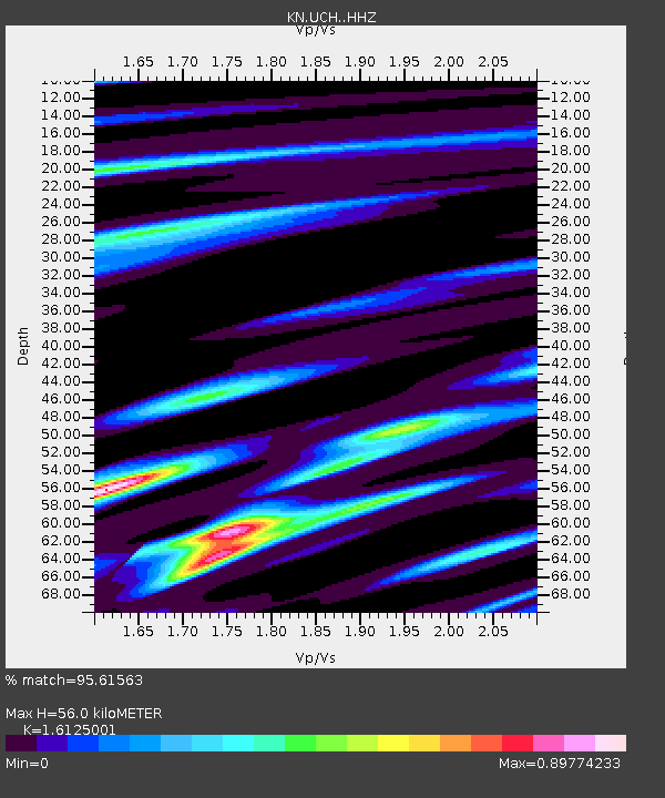
| Estimated Moho Depth: |
56.0 km |
| Estimated Crust Vp/Vs: |
1.61 |
| Assumed Crust Vp: |
6.306 km/s |
| Estimated Crust Vs: |
3.911 km/s |
| Estimated Crust Poisson's Ratio: |
0.19 |
|
| Radial Match: |
95.61563 % |
| Radial Bump: |
308 |
| Transverse Match: |
85.570786 % |
| Transverse Bump: |
400 |
| SOD ConfigId: |
3390531 |
| Insert Time: |
2019-04-12 19:32:25.025 +0000 |
| GWidth: |
2.5 |
| Max Bumps: |
400 |
| Tol: |
0.001 |
|

Signal To Noise
| Channel | StoN | STA | LTA |
| KN:UCH: :HHZ:20140711T19:30:32.89002Z | 43.67814 | 2.9242722E-6 | 6.695048E-8 |
| KN:UCH: :HHN:20140711T19:30:32.89002Z | 7.2205586 | 6.189514E-7 | 8.572071E-8 |
| KN:UCH: :HHE:20140711T19:30:32.89002Z | 29.238167 | 1.3729266E-6 | 4.6956657E-8 |
| Arrivals |
| Ps | 5.8 SECOND |
| PpPs | 22 SECOND |
| PsPs/PpSs | 28 SECOND |


