You are here: Home > Network List > TA - USArray Transportable Network (new EarthScope stations) Stations List
> Station X43A Marvell, AR, USA > Earthquake Result Viewer
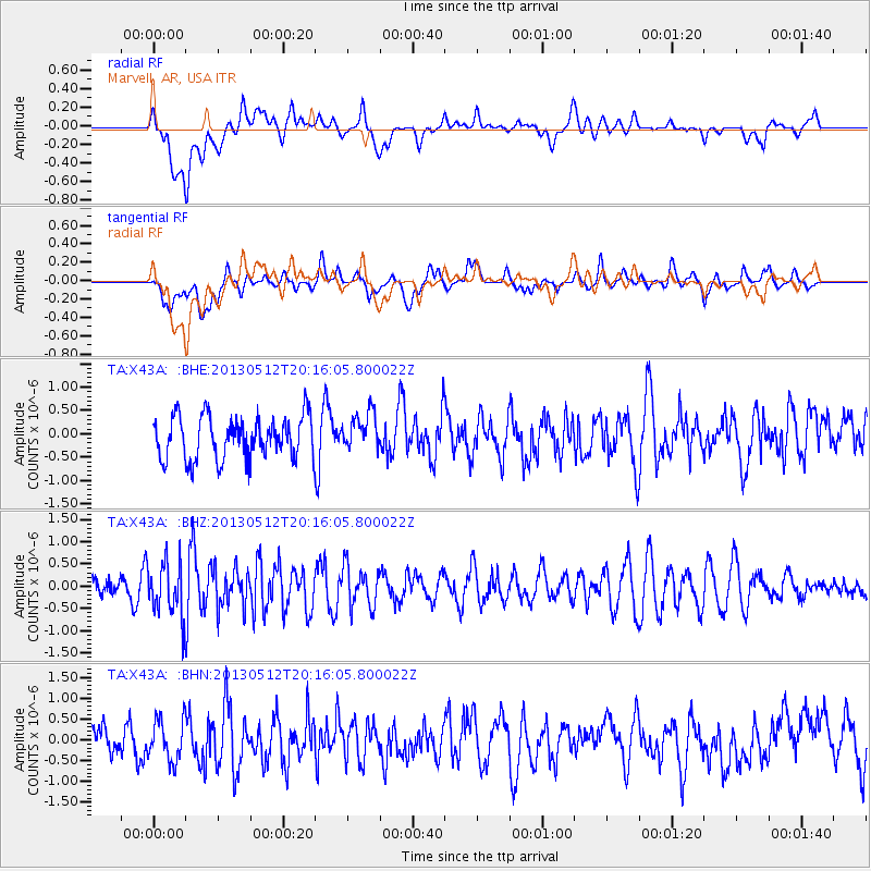
X43A Marvell, AR, USA - Earthquake Result Viewer
*The percent match for this event was below the threshold and hence no stack was calculated.
| Earthquake location: |
Fox Islands, Aleutian Islands |
| Earthquake latitude/longitude: |
52.5/-172.0 |
| Earthquake time(UTC): |
2013/05/12 (132) 20:06:41 GMT |
| Earthquake Depth: |
8.0 km |
| Earthquake Magnitude: |
5.7 MB, 5.1 MS, 5.4 MW, 5.3 MW |
| Earthquake Catalog/Contributor: |
WHDF/NEIC |
|
| Network: |
TA USArray Transportable Network (new EarthScope stations) |
| Station: |
X43A Marvell, AR, USA |
| Lat/Lon: |
34.52 N/90.88 W |
| Elevation: |
53 m |
|
| Distance: |
58.4 deg |
| Az: |
73.382 deg |
| Baz: |
314.808 deg |
| Ray Param: |
$rayparam |
*The percent match for this event was below the threshold and hence was not used in the summary stack. |
|
| Radial Match: |
36.3235 % |
| Radial Bump: |
400 |
| Transverse Match: |
44.751587 % |
| Transverse Bump: |
400 |
| SOD ConfigId: |
508211 |
| Insert Time: |
2013-07-12 10:06:41.012 +0000 |
| GWidth: |
2.5 |
| Max Bumps: |
400 |
| Tol: |
0.001 |
|
Signal To Noise
| Channel | StoN | STA | LTA |
| TA:X43A: :BHZ:20130512T20:16:05.800022Z | 1.656288 | 6.1082056E-7 | 3.6878885E-7 |
| TA:X43A: :BHN:20130512T20:16:05.800022Z | 1.2943729 | 4.9722536E-7 | 3.8414382E-7 |
| TA:X43A: :BHE:20130512T20:16:05.800022Z | 0.8889804 | 4.0590604E-7 | 4.5659732E-7 |
| Arrivals |
| Ps | |
| PpPs | |
| PsPs/PpSs | |


