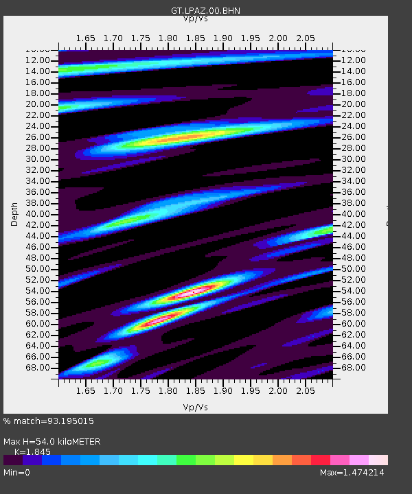
LPAZ La Paz , Bolivia - Earthquake Result Viewer

Earthquake location: Central Mid-Atlantic Ridge
Earthquake latitude/longitude: 0.7/-30.3
Earthquake time(UTC): 2007/07/03 (184) 08:26:00 GMT
Earthquake Depth: 10 km
Earthquake Magnitude: 5.8 MB, 5.9 MS, 6.3 MW, 6.1 MW
Earthquake Catalog/Contributor: WHDF/NEIC
Network: GT Global Telemetered Seismograph Network (USAF/USGS)
Station: LPAZ La Paz , Bolivia
Lat/Lon: 16.17 S/68.08 W
Elevation: 4817 m
Distance: 40.9 deg
Az: 244.086 deg
Baz: 69.383 deg
Ray Param: 0.0741196
Estimated Moho Depth: 54.0 km
Estimated Crust Vp/Vs: 1.85
Assumed Crust Vp: 6.454 km/s
Estimated Crust Vs: 3.498 km/s
Estimated Crust Poisson's Ratio: 0.29
Radial Match: 93.195015 %
Radial Bump: 393
Transverse Match: 81.17314 %
Transverse Bump: 400
SOD ConfigId: 2564
Insert Time: 2010-02-27 02:10:19.267 +0000
GWidth: 2.5
Max Bumps: 400
Tol: 0.001

Signal To Noise

ChannelStoNSTALTA
GT:LPAZ:00:BHN:20070703T08:33:12.299014Z2.43828341.3130284E-75.3850524E-8
GT:LPAZ:00:BHE:20070703T08:33:12.299014Z5.14346653.2851165E-76.38697E-8
GT:LPAZ:00:BHZ:20070703T08:33:12.299014Z8.4123956.3590943E-77.559196E-8
Arrivals
Ps7.6 SECOND
PpPs22 SECOND
PsPs/PpSs30 SECOND