You are here: Home > Network List > GT - Global Telemetered Seismograph Network (USAF/USGS) Stations List
> Station LPAZ La Paz , Bolivia > Earthquake Result Viewer
LPAZ La Paz , Bolivia - Earthquake Result Viewer
| Earthquake location: |
Cuba Region |
| Earthquake latitude/longitude: |
19.4/-78.5 |
| Earthquake time(UTC): |
2007/02/04 (035) 20:56:59 GMT |
| Earthquake Depth: |
10 km |
| Earthquake Magnitude: |
5.7 MB, 5.9 MS, 6.2 MW, 6.2 MW |
| Earthquake Catalog/Contributor: |
WHDF/NEIC |
|
| Network: |
GT Global Telemetered Seismograph Network (USAF/USGS) |
| Station: |
LPAZ La Paz , Bolivia |
| Lat/Lon: |
16.17 S/68.08 W |
| Elevation: |
4817 m |
|
| Distance: |
36.8 deg |
| Az: |
163.095 deg |
| Baz: |
343.4 deg |
| Ray Param: |
0.07649216 |
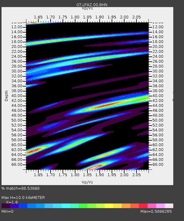
| Estimated Moho Depth: |
10.0 km |
| Estimated Crust Vp/Vs: |
1.60 |
| Assumed Crust Vp: |
6.454 km/s |
| Estimated Crust Vs: |
4.034 km/s |
| Estimated Crust Poisson's Ratio: |
0.18 |
|
| Radial Match: |
88.53868 % |
| Radial Bump: |
326 |
| Transverse Match: |
67.07614 % |
| Transverse Bump: |
400 |
| SOD ConfigId: |
2564 |
| Insert Time: |
2010-02-27 02:10:20.992 +0000 |
| GWidth: |
2.5 |
| Max Bumps: |
400 |
| Tol: |
0.001 |
|
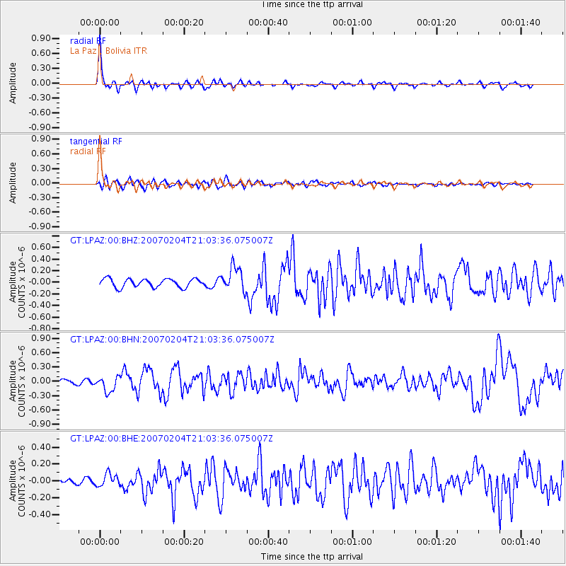
Signal To Noise
| Channel | StoN | STA | LTA |
| GT:LPAZ:00:BHN:20070204T21:03:36.075007Z | 2.9342067 | 1.6470194E-7 | 5.6131675E-8 |
| GT:LPAZ:00:BHE:20070204T21:03:36.075007Z | 1.387923 | 7.807756E-8 | 5.6254965E-8 |
| GT:LPAZ:00:BHZ:20070204T21:03:36.075007Z | 2.9441519 | 2.1388665E-7 | 7.2647964E-8 |
| Arrivals |
| Ps | 1.0 SECOND |
| PpPs | 3.7 SECOND |
| PsPs/PpSs | 4.7 SECOND |


