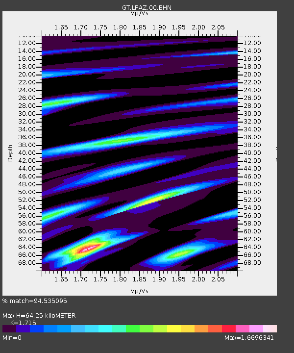
LPAZ La Paz , Bolivia - Earthquake Result Viewer
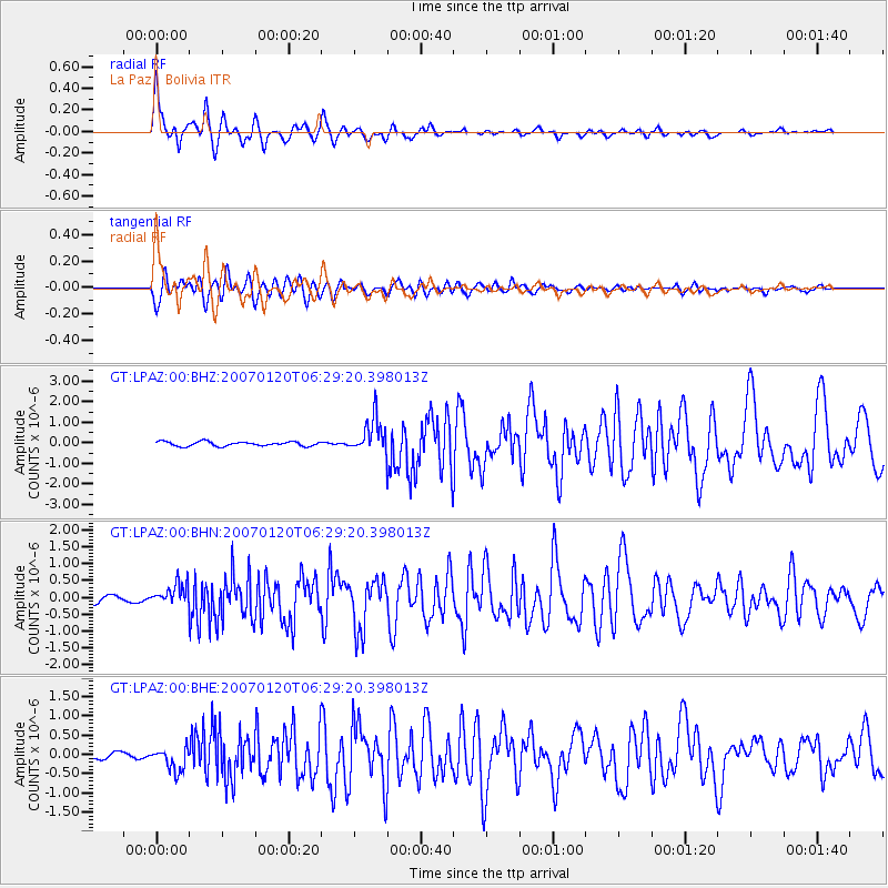
Earthquake location: South Sandwich Islands Region
Earthquake latitude/longitude: -55.4/-29.5
Earthquake time(UTC): 2007/01/20 (020) 06:21:04 GMT
Earthquake Depth: 10 km
Earthquake Magnitude: 5.7 MB, 6.2 MS, 6.2 MW, 6.1 MW
Earthquake Catalog/Contributor: WHDF/NEIC
Network: GT Global Telemetered Seismograph Network (USAF/USGS)
Station: LPAZ La Paz , Bolivia
Lat/Lon: 16.17 S/68.08 W
Elevation: 4817 m
Distance: 49.0 deg
Az: 307.508 deg
Baz: 151.922 deg
Ray Param: 0.06897897
Estimated Moho Depth: 64.25 km
Estimated Crust Vp/Vs: 1.72
Assumed Crust Vp: 6.454 km/s
Estimated Crust Vs: 3.763 km/s
Estimated Crust Poisson's Ratio: 0.24
Radial Match: 94.535095 %
Radial Bump: 367
Transverse Match: 85.58858 %
Transverse Bump: 400
SOD ConfigId: 2564
Insert Time: 2010-02-27 02:10:22.714 +0000
GWidth: 2.5
Max Bumps: 400
Tol: 0.001

Signal To Noise

ChannelStoNSTALTA
GT:LPAZ:00:BHN:20070120T06:29:20.398013Z3.67996863.1874276E-78.661562E-8
GT:LPAZ:00:BHE:20070120T06:29:20.398013Z4.0073273.0178154E-77.530744E-8
GT:LPAZ:00:BHZ:20070120T06:29:20.398013Z7.83413468.439466E-71.0772685E-7
Arrivals
Ps7.6 SECOND
PpPs25 SECOND
PsPs/PpSs33 SECOND