You are here: Home > Network List > TA - USArray Transportable Network (new EarthScope stations) Stations List
> Station G42A Mountain, WI, USA > Earthquake Result Viewer
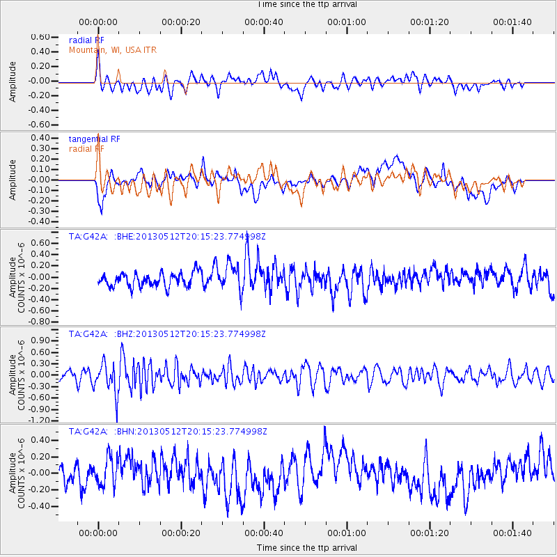
G42A Mountain, WI, USA - Earthquake Result Viewer
*The percent match for this event was below the threshold and hence no stack was calculated.
| Earthquake location: |
Fox Islands, Aleutian Islands |
| Earthquake latitude/longitude: |
52.5/-172.0 |
| Earthquake time(UTC): |
2013/05/12 (132) 20:06:41 GMT |
| Earthquake Depth: |
8.0 km |
| Earthquake Magnitude: |
5.7 MB, 5.1 MS, 5.4 MW, 5.3 MW |
| Earthquake Catalog/Contributor: |
WHDF/NEIC |
|
| Network: |
TA USArray Transportable Network (new EarthScope stations) |
| Station: |
G42A Mountain, WI, USA |
| Lat/Lon: |
45.24 N/88.43 W |
| Elevation: |
315 m |
|
| Distance: |
52.5 deg |
| Az: |
62.231 deg |
| Baz: |
310.032 deg |
| Ray Param: |
$rayparam |
*The percent match for this event was below the threshold and hence was not used in the summary stack. |
|
| Radial Match: |
48.661636 % |
| Radial Bump: |
400 |
| Transverse Match: |
37.458878 % |
| Transverse Bump: |
400 |
| SOD ConfigId: |
508211 |
| Insert Time: |
2013-07-12 10:10:02.077 +0000 |
| GWidth: |
2.5 |
| Max Bumps: |
400 |
| Tol: |
0.001 |
|
Signal To Noise
| Channel | StoN | STA | LTA |
| TA:G42A: :BHZ:20130512T20:15:23.774998Z | 2.552542 | 3.9651079E-7 | 1.5533958E-7 |
| TA:G42A: :BHN:20130512T20:15:23.774998Z | 1.5739933 | 1.7480869E-7 | 1.1106063E-7 |
| TA:G42A: :BHE:20130512T20:15:23.774998Z | 1.9605664 | 2.3792431E-7 | 1.2135489E-7 |
| Arrivals |
| Ps | |
| PpPs | |
| PsPs/PpSs | |


