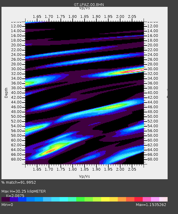
LPAZ La Paz , Bolivia - Earthquake Result Viewer
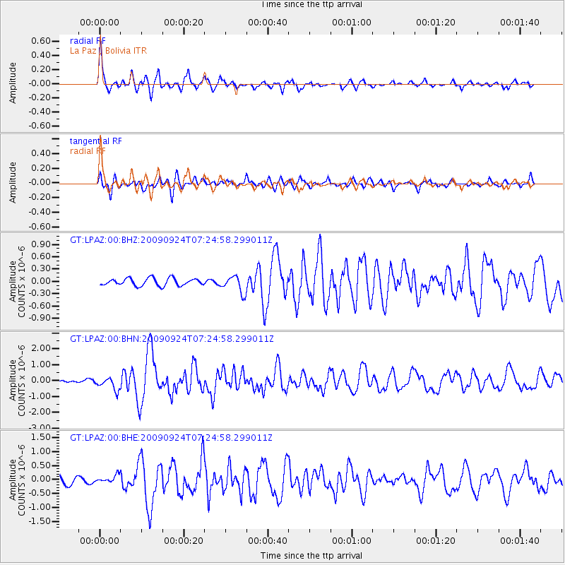
Earthquake location: Off Coast Of Jalisco, Mexico
Earthquake latitude/longitude: 18.8/-107.3
Earthquake time(UTC): 2009/09/24 (267) 07:16:19 GMT
Earthquake Depth: 10 km
Earthquake Magnitude: 5.8 MB, 6.2 MS, 6.3 MW, 6.3 MW
Earthquake Catalog/Contributor: WHDF/NEIC
Network: GT Global Telemetered Seismograph Network (USAF/USGS)
Station: LPAZ La Paz , Bolivia
Lat/Lon: 16.17 S/68.08 W
Elevation: 4817 m
Distance: 52.0 deg
Az: 129.467 deg
Baz: 310.452 deg
Ray Param: 0.06705402
Estimated Moho Depth: 30.25 km
Estimated Crust Vp/Vs: 2.09
Assumed Crust Vp: 6.454 km/s
Estimated Crust Vs: 3.092 km/s
Estimated Crust Poisson's Ratio: 0.35
Radial Match: 91.9952 %
Radial Bump: 400
Transverse Match: 83.53871 %
Transverse Bump: 400
SOD ConfigId: 2622
Insert Time: 2010-02-27 02:10:24.857 +0000
GWidth: 2.5
Max Bumps: 400
Tol: 0.001

Signal To Noise

ChannelStoNSTALTA
GT:LPAZ:00:BHN:20090924T07:24:58.299011Z4.8793654.0183548E-78.2354056E-8
GT:LPAZ:00:BHE:20090924T07:24:58.299011Z1.10861651.456831E-71.3140983E-7
GT:LPAZ:00:BHZ:20090924T07:24:58.299011Z2.22332481.980061E-78.905856E-8
Arrivals
Ps5.3 SECOND
PpPs14 SECOND
PsPs/PpSs19 SECOND