You are here: Home > Network List > TA - USArray Transportable Network (new EarthScope stations) Stations List
> Station W46A Michie, TN, USA > Earthquake Result Viewer
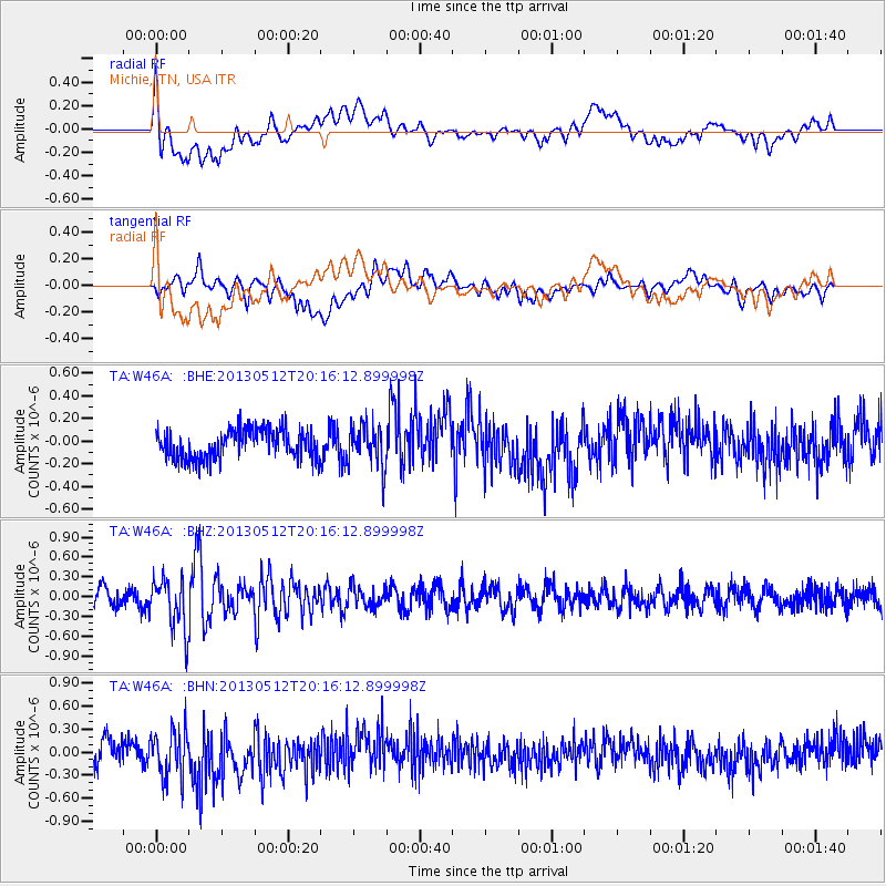
W46A Michie, TN, USA - Earthquake Result Viewer
*The percent match for this event was below the threshold and hence no stack was calculated.
| Earthquake location: |
Fox Islands, Aleutian Islands |
| Earthquake latitude/longitude: |
52.5/-172.0 |
| Earthquake time(UTC): |
2013/05/12 (132) 20:06:41 GMT |
| Earthquake Depth: |
8.0 km |
| Earthquake Magnitude: |
5.7 MB, 5.1 MS, 5.4 MW, 5.3 MW |
| Earthquake Catalog/Contributor: |
WHDF/NEIC |
|
| Network: |
TA USArray Transportable Network (new EarthScope stations) |
| Station: |
W46A Michie, TN, USA |
| Lat/Lon: |
35.13 N/88.38 W |
| Elevation: |
145 m |
|
| Distance: |
59.4 deg |
| Az: |
71.175 deg |
| Baz: |
315.09 deg |
| Ray Param: |
$rayparam |
*The percent match for this event was below the threshold and hence was not used in the summary stack. |
|
| Radial Match: |
49.135597 % |
| Radial Bump: |
400 |
| Transverse Match: |
60.344124 % |
| Transverse Bump: |
400 |
| SOD ConfigId: |
508211 |
| Insert Time: |
2013-07-12 10:13:34.739 +0000 |
| GWidth: |
2.5 |
| Max Bumps: |
400 |
| Tol: |
0.001 |
|
Signal To Noise
| Channel | StoN | STA | LTA |
| TA:W46A: :BHZ:20130512T20:16:12.899998Z | 2.8340354 | 3.9862945E-7 | 1.4065789E-7 |
| TA:W46A: :BHN:20130512T20:16:12.899998Z | 2.0035324 | 3.1287823E-7 | 1.561633E-7 |
| TA:W46A: :BHE:20130512T20:16:12.899998Z | 1.4067942 | 1.8153672E-7 | 1.2904285E-7 |
| Arrivals |
| Ps | |
| PpPs | |
| PsPs/PpSs | |


